File:Trois ligues.png
Jump to navigation
Jump to search

Size of this preview: 642 × 599 pixels. Other resolutions: 257 × 240 pixels | 514 × 480 pixels | 823 × 768 pixels | 1,097 × 1,024 pixels | 1,959 × 1,828 pixels.
Original file (1,959 × 1,828 pixels, file size: 231 KB, MIME type: image/png)
Captions
Captions
Add a one-line explanation of what this file represents
Summary[edit]
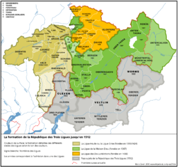
| Description | Die Entstehung des Freistaats der Drei Bünde bis 1512 | |
| Date | ||
| Source | own work; basiert auf: Adolf Gasser und Ernst Keller, Historische Karte zur territorialen Entwicklung der Schweizerischen Eidgenossenschaft 1291–1797. o.O. 1932 und Hektor Amman / Karl Schib (Hrsg.): Historischer Atlas der Schweiz. Sauerländer, Aarau 1958, 41. | |
| Author | Marco Zanoli (sidonius 15:49, 30 June 2006 (UTC)) | |
| Permission (Reusing this file) |
|
|
| Other versions |
 |
Licensing[edit]
I, the copyright holder of this work, hereby publish it under the following license:
This file is licensed under the Creative Commons Attribution-Share Alike 2.5 Generic license.
- You are free:
- to share – to copy, distribute and transmit the work
- to remix – to adapt the work
- Under the following conditions:
- attribution – You must give appropriate credit, provide a link to the license, and indicate if changes were made. You may do so in any reasonable manner, but not in any way that suggests the licensor endorses you or your use.
- share alike – If you remix, transform, or build upon the material, you must distribute your contributions under the same or compatible license as the original.
File history
Click on a date/time to view the file as it appeared at that time.
| Date/Time | Thumbnail | Dimensions | User | Comment | |
|---|---|---|---|---|---|
| current | 12:54, 3 May 2007 | | 1,959 × 1,828 (231 KB) | Philippe317~commonswiki (talk | contribs) | {{Information |Description=Die Entstehung des Freistaats der Drei Bünde bis 1512 |Source=own work; basiert auf: Adolf Gasser und Ernst Keller, Historische Karte zur territorialen Entwicklung der Schweizerischen Eidgenossenschaft 1291–1797. o.O. 1932 u |
| 12:47, 3 May 2007 |  | 1,959 × 1,828 (231 KB) | Philippe317~commonswiki (talk | contribs) | {{Information |Description=Die Entstehung des Freistaats der Drei Bünde bis 1512 |Source=own work; basiert auf: Adolf Gasser und Ernst Keller, Historische Karte zur territorialen Entwicklung der Schweizerischen Eidgenossenschaft 1291–1797. o.O. 1932 u |
You cannot overwrite this file.
File usage on Commons
There are no pages that use this file.
File usage on other wikis
The following other wikis use this file:
- Usage on ca.wikipedia.org
- Usage on en.wikipedia.org
- Usage on fr.wikipedia.org
- Usage on ja.wikipedia.org
- Usage on ko.wikipedia.org
- Usage on mk.wikipedia.org
- Usage on mt.wikipedia.org
- Usage on pt.wikipedia.org
- Usage on ru.wikipedia.org
- Usage on sl.wikipedia.org
- Usage on uk.wikipedia.org
- Usage on www.wikidata.org
- Usage on zh.wikipedia.org