File:Tuninter TS-LBB route.png
Jump to navigation
Jump to search

Size of this preview: 503 × 600 pixels. Other resolutions: 201 × 240 pixels | 402 × 480 pixels | 913 × 1,089 pixels.
Original file (913 × 1,089 pixels, file size: 1.65 MB, MIME type: image/png)
Captions
Captions
Add a one-line explanation of what this file represents
Summary[edit]
Summary:[edit]
| Description |
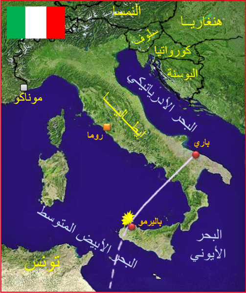
English: Tuninter Flight 1153 was a Tuninter flight from Bari International Airport in Bari, Italy, to Djerba-Zarzis Airport in Djerba, Tunisia. On 6 August 2005 the ATR-72 on the route, TS-LBB "Habib Bourguiba", ran out of fuel and ditched into the sea. (Arabic)
Français : Le vol 1153 Tuninter (ATR-72) connaît un crash aérien le 6 août 2005 au large de la Sicile (mer Méditerranée). Il s'agit du premier et seul incident grave pour la compagnie tunisienne Tuninter. (Arabe)
العربية: مسار طائرة رحلة رقم 1153 التابعة لشركة الخطوط الدولية التونسية وهي من نوع ATR 72 ورقم التسجيل هو TS-LBB ، كانت في رحلة من مطار باري الدولي في مدينة باري الإيطالية إلى مطار جربة جرجيس الدولي بجزيرة جربة التونسية. سقطت بالبحر بتاريخ 6 أغسطس 2005 بعد نفاد الوقود. كابتن الطائرة واسمه شفيق الغربي ومساعده المدعو علي كبيّر الأسود. (الْعَرَبيّة)
Italiano: Il Volo Tuninter 1153 era un volo charter che decollò dall'Aeroporto di Bari il 6 agosto 2005, con destinazione Gerba, operato dalla compagnia aerea tunisina Tuninter. L'aereo, un ATR 72, effettuò un ammaraggio di fortuna alle 13:37 UTC al largo della costa di Punta Raisi aeroporto di Palermo, dopo aver dichiarato emergenza. (Araba) |
| Date | (UTC) |
| Source | |
| Author |
|
| Other versions |
|


Added info[edit]
| This is a retouched picture, which means that it has been digitally altered from its original version. Modifications: Added information about the rout of Tuninter Flight 1153. The original can be viewed here: Carte ITALIE R2.jpg:
|
Licensing[edit]
| This file is in the public domain in the United States because it was solely created by NASA. NASA copyright policy states that "NASA material is not protected by copyright unless noted". (See Template:PD-USGov, NASA copyright policy page or JPL Image Use Policy.) | ||
 |
Warnings:
|
Original upload log[edit]
This image is a derivative work of the following images:
- File:Carte_ITALIE_R2.jpg licensed with PD-USGov-NASA
- 2008-12-29T10:30:24Z Wikisoft* 466x573 (63913 Bytes) {{Information |Description={{fr|1=Carte satellite radar NASA reformatée pour la Géolocalisation}} |Source=Carte satellite radar NASA |Author=~~~~ |Date=29/12/2008 |Permission= |other_versions=[[Italie]] }}
Uploaded with derivativeFX
Categories:[edit]
File history
Click on a date/time to view the file as it appeared at that time.
| Date/Time | Thumbnail | Dimensions | User | Comment | |
|---|---|---|---|---|---|
| current | 21:59, 18 April 2009 | | 913 × 1,089 (1.65 MB) | Producer (talk | contribs) | {{Information |Description={{fr|1=Carte satellite radar NASA reformatée pour la Géolocalisation}} |Source=*File:Carte_ITALIE_R2.jpg |Date=2009-04-18 22:53 (UTC) |Author=*File:Carte_ITALIE_R2.jpg: ''Wikisoft* [[User talk:Wi |
You cannot overwrite this file.
File usage on Commons
The following 4 pages use this file:
File usage on other wikis
The following other wikis use this file:
- Usage on ar.wikipedia.org
- Usage on fr.wikipedia.org
- Usage on pl.wikipedia.org
- Usage on ru.wikipedia.org