File:Turecko Nemrut Dağı (03).jpg
Jump to navigation
Jump to search

Size of this preview: 800 × 536 pixels. Other resolutions: 320 × 214 pixels | 640 × 428 pixels | 1,024 × 685 pixels | 1,280 × 857 pixels | 2,560 × 1,714 pixels | 3,872 × 2,592 pixels.
Original file (3,872 × 2,592 pixels, file size: 6.58 MB, MIME type: image/jpeg)
Captions
Captions
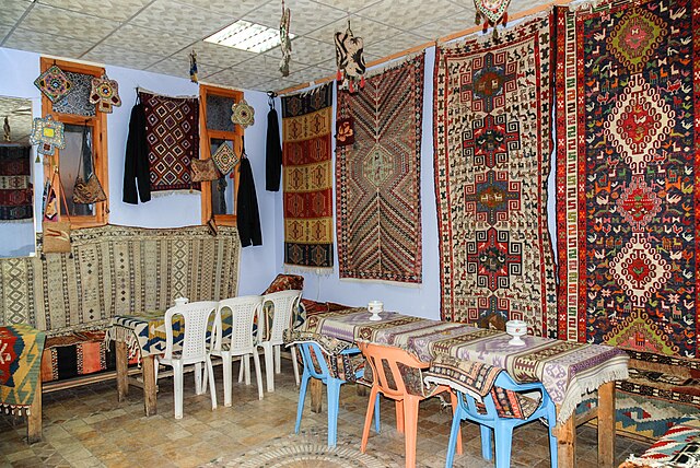
A teahouse by the car park below the top of the Mount Nemrtut (Tur. Nemrut Dağı), Kâhta District, Adıyaman Province, Turkey
Summary[edit]
.jpg&action=edit§ion=1)
| Description |
Čeština: Čajovna u parkoviště pod vrcholem hory Nemrtut (tur. Nemrut Dağı), okres Kâhta, provincie Adıyaman, Turecko
English: A teahouse by the car park below the top of the Mount Nemrtut (Tur. Nemrut Dağı), Kâhta District, Adıyaman Province, Turkey |
| Date | |
| Source | Own work |
| Author | Zorka Sojka |
| Camera location | | View this and other nearby images on: OpenStreetMap |
|---|
.jpg¶ms=037.976458_N_0038.737435_E_globe:Earth_type:camera__&language=en)
Licensing[edit]
.jpg&action=edit§ion=2)
I, the copyright holder of this work, hereby publish it under the following license:
This file is licensed under the Creative Commons Attribution-Share Alike 4.0 International license.
- You are free:
- to share – to copy, distribute and transmit the work
- to remix – to adapt the work
- Under the following conditions:
- attribution – You must give appropriate credit, provide a link to the license, and indicate if changes were made. You may do so in any reasonable manner, but not in any way that suggests the licensor endorses you or your use.
- share alike – If you remix, transform, or build upon the material, you must distribute your contributions under the same or compatible license as the original.
File history
Click on a date/time to view the file as it appeared at that time.
| Date/Time | Thumbnail | Dimensions | User | Comment | |
|---|---|---|---|---|---|
| current | 07:20, 7 February 2022 | | 3,872 × 2,592 (6.58 MB) | Zorka Sojka (talk | contribs) | Uploaded own work with UploadWizard |
You cannot overwrite this file.
File usage on Commons
There are no pages that use this file.
.jpg&oldid=629692643)