File:Turkish Strait disambig(Turkish).svg
Jump to navigation
Jump to search

Size of this PNG preview of this SVG file: 469 × 388 pixels. Other resolutions: 290 × 240 pixels | 580 × 480 pixels | 928 × 768 pixels | 1,238 × 1,024 pixels | 2,476 × 2,048 pixels.
Original file (SVG file, nominally 469 × 388 pixels, file size: 93 KB)
Captions
Captions
Add a one-line explanation of what this file represents
Summary[edit]
| Description |
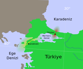
Hrvatski: Tjesnaci Bospor i Dardaneli Türkçe: Türk Boğazlarının harita üzerinde renkledirme ile açıklaması
Ελληνικά: τα Στενά του Βοσπόρου Українська: Турецькі протоки.
Босфор
Дарданелли मराठी: तुर्कस्तानमधील बोस्फोरस व डार्डेनेल्झ ह्या सामुद्रधुन्या 日本語: 海峡地帯(トルコ) |
||
| Date | |||
| Source | Own work based on: Turkish Strait disambig.svg | ||
| Author | Thomas Steiner, User:Interiot, Thiamine | ||
| Other versions |
[]
|


.svg)


.svg&action=edit§ion=1)
Licensing[edit]
.svg&action=edit§ion=2)
I, the copyright holder of this work, hereby publish it under the following license:
This file is licensed under the Creative Commons Attribution-Share Alike 3.0 Unported license.
- You are free:
- to share – to copy, distribute and transmit the work
- to remix – to adapt the work
- Under the following conditions:
- attribution – You must give appropriate credit, provide a link to the license, and indicate if changes were made. You may do so in any reasonable manner, but not in any way that suggests the licensor endorses you or your use.
- share alike – If you remix, transform, or build upon the material, you must distribute your contributions under the same or compatible license as the original.
File history
Click on a date/time to view the file as it appeared at that time.
| Date/Time | Thumbnail | Dimensions | User | Comment | |
|---|---|---|---|---|---|
| current | 18:24, 26 June 2013 | | 469 × 388 (93 KB) | Thiamine (talk | contribs) | User created page with UploadWizard |
You cannot overwrite this file.
File usage on Commons
The following 13 pages use this file:
- File:Black Sea Straits rus.png
- File:Black sea Map-Masry.PNG
- File:Turkish Strait disambig(Turkish).svg
- File:Turkish Strait disambig.svg
- File:Turkish Strait disambig AR.png
- File:Turkish Strait disambig es.svg
- File:Turkish Strait disambig hr.svg
- File:Turkish Strait disambig hu.svg
- File:Turkish Strait disambig ja.svg
- File:Turkish Strait disambig mk.svg
- File:Turkish Strait disambig uk.svg
- File:बोस्फोरस डार्डेनेल्झ.png
- Template:Other versions/Turkish Strait
File usage on other wikis
The following other wikis use this file:
- Usage on tr.wikipedia.org
- Usage on tr.wiktionary.org
- Usage on uz.wikipedia.org
.svg&oldid=845190269)