File:Tuuru-Puise tee kaart.png
Jump to navigation
Jump to search
No higher resolution available.
Tuuru-Puise_tee_kaart.png (585 × 455 pixels, file size: 18 KB, MIME type: image/png)
Captions
Captions
Add a one-line explanation of what this file represents
Summary[edit]
| Description |
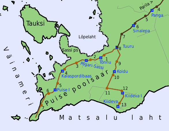
Eesti: Tuuru-Puise tee kaart vastavalt Maa-ameti kaardiserveri Maanteeameti kaardirakendusele. Siniselt bussipeatused, täpid teel on kilomeetripunktid. Tumedamalt mustkattega, heledamalt kruusakattega teed. Kaardil ka Parila-Kiideva tee lõpuosa. Mõõtkava puudub, selle kohta saab aimu kilomeetripunktidest. |
| Date | |
| Source | Own work by the original uploader |
| Author | Jaan513 |
Licensing[edit]

|
The copyright holder of this work allows anyone to use it for any purpose including unrestricted redistribution, commercial use, and modification.
Usage notes:
|
Original upload log[edit]
The original description page was here. All following user names refer to et.wikipedia.
| Date/Time | Dimensions | User | Comment |
|---|---|---|---|
| 15:21, 9 June 2009 | 585 × 455 (18,116 bytes) | Jaan513 | '''Tuuru-Puise tee kaart''' vastavalt Maa-ameti kaardiserveri Maanteeameti kaardirakendusele. Siniselt bussipeatused, täpid teel on kilomeetripunktid. Tumedamalt mustkattega, heledamalt kruusakattega teed. Kaardil ka Parila-Kiideva tee lõpuosa. Mõõtk |
File history
Click on a date/time to view the file as it appeared at that time.
| Date/Time | Thumbnail | Dimensions | User | Comment | |
|---|---|---|---|---|---|
| current | 13:40, 28 March 2014 | | 585 × 455 (18 KB) | Pikne (talk | contribs) | Transferred from et.wikipedia: see original upload log above |
You cannot overwrite this file.
File usage on Commons
There are no pages that use this file.
File usage on other wikis
The following other wikis use this file:
- Usage on et.wikipedia.org