File:Two of China’s most populous cities--Beijing and Tianjin.jpg
Jump to navigation
Jump to search
Size of this preview: 800 × 548 pixels. Other resolutions: 320 × 219 pixels | 640 × 438 pixels | 1,024 × 701 pixels | 1,280 × 876 pixels | 2,560 × 1,752 pixels | 4,256 × 2,913 pixels.
Original file (4,256 × 2,913 pixels, file size: 1.53 MB, MIME type: image/jpeg)
Captions
Captions
Add a one-line explanation of what this file represents
Summary
[edit]
| Description |
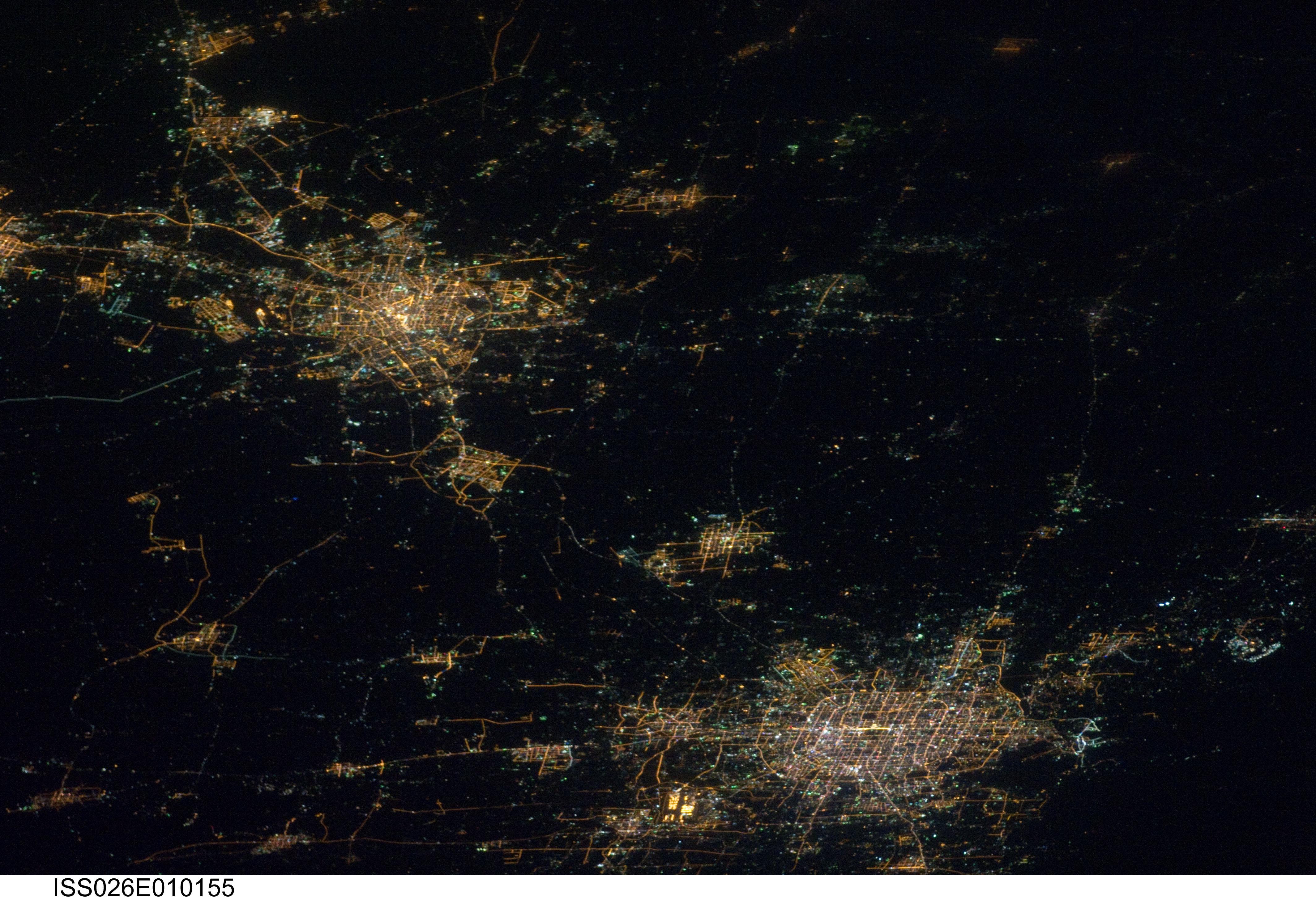
English: This striking photograph features two of China’s most populous cities--Beijing and Tianjin--both located in the northern part of the country near the Bohai Gulf. The United Nations estimated 2010 population for the Beijing metropolitan area is approximately 12 million, with the population of the Tianjin metropolitan area estimated to be over 7 million.
Taken at night time by the Expedition 26 crew, the image dramatically illustrates the extent of both metropolitan areas. The smaller city of Langfang, located midway between Beijing and Tianjin, also is clearly visible, as are several other smaller developed areas to the northeast. The dark regions surrounding the well-lit urban areas are mainly agricultural fields, with wheat and corn being the major crops. Beijing is one of the recognized ancient capital cities--and the current capital--of the People’s Republic of China. The regular grid pattern of the city is clearly visible at lower upper right; concentric rings of major roadways around the city center have been added as the metropolitan area has expanded. Tianjin is a major trade center with connection to seaports on the Bohai Gulf. The city was established following the integration of the Grand Canal of China, a major artificial waterway extending from Beijing southwards to Hangzhou. |
| Source | http://www.nasa.gov/multimedia/imagegallery/image_feature_1831.html |
| Author | NASA |
Fuente:
[edit]
http://www.nasa.gov/multimedia/imagegallery/image_feature_1831.html
Licensing
[edit]
| This file is in the public domain in the United States because it was solely created by NASA. NASA copyright policy states that "NASA material is not protected by copyright unless noted". (See Template:PD-USGov, NASA copyright policy page or JPL Image Use Policy.) | ||
 |
Warnings:
|
File history
Click on a date/time to view the file as it appeared at that time.
| Date/Time | Thumbnail | Dimensions | User | Comment | |
|---|---|---|---|---|---|
| current | 13:57, 28 December 2010 | | 4,256 × 2,913 (1.53 MB) | Emijrp (talk | contribs) | == {{int:filedesc}} == {{Information |Description={{en|1=This striking photograph features two of China’s most populous cities--Beijing and Tianjin--both located in the northern part of the country near the Bohai Gulf. The United Nations estimated 201 |
You cannot overwrite this file.
File usage on Commons
The following page uses this file:
- File:507690main iss026e010155 full.jpg (file redirect)