File:UAEOMCmap-ar.png
Jump to navigation
Jump to search

Size of this preview: 671 × 599 pixels. Other resolutions: 269 × 240 pixels | 537 × 480 pixels | 928 × 829 pixels.
Original file (928 × 829 pixels, file size: 73 KB, MIME type: image/png)
Captions
Captions
Add a one-line explanation of what this file represents
Summary[edit]
| Description |
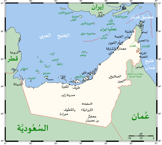
العربية: خريطة تُظهر مُدن دولة الإمارات العربيَّة المُتحدة الرئيسيَّة بِالإضافة لِبلداتها الرئيسيَّة والمناطق المُجاورة. |
| Date | |
| Source | Derivative from: this file |
| Author |
|
| Other versions | English |
| This is a retouched picture, which means that it has been digitally altered from its original version. Modifications: Translated to Arabic - عُرِبَت. The original can be viewed here: UAEOMCmap.png:
|
Licensing[edit]
Kelisi at the English-language Wikipedia, the copyright holder of this work, hereby publishes it under the following license:
| This file is licensed under the Creative Commons Attribution-Share Alike 3.0 Unported license. Subject to disclaimers. | ||
| Attribution: Kelisi at the English-language Wikipedia | ||
| ||
| This licensing tag was added to this file as part of the GFDL licensing update. |

|
Permission is granted to copy, distribute and/or modify this document under the terms of the GNU Free Documentation License, Version 1.2 or any later version published by the Free Software Foundation; with no Invariant Sections, no Front-Cover Texts, and no Back-Cover Texts. A copy of the license is included in the section entitled GNU Free Documentation License. Subject to disclaimers. |
File history
Click on a date/time to view the file as it appeared at that time.
| Date/Time | Thumbnail | Dimensions | User | Comment | |
|---|---|---|---|---|---|
| current | 18:08, 30 January 2021 | | 928 × 829 (73 KB) | Kelisi (talk | contribs) | The Saudi-Qatari border has been adjusted to reflect what current maps generally show. Source was Open Street Map, which I always find to be the trustworthiest in such matters (and, of course, the freest as well; so there is no copyright to worry about). |
| 20:10, 28 January 2017 |  | 928 × 829 (73 KB) | باسم (talk | contribs) | User created page with UploadWizard |
You cannot overwrite this file.
File usage on Commons
There are no pages that use this file.
File usage on other wikis
The following other wikis use this file:
- Usage on ar.wikipedia.org