File:UAE ja-map.png
Jump to navigation
Jump to search

Size of this preview: 800 × 565 pixels. Other resolutions: 320 × 226 pixels | 640 × 452 pixels | 1,024 × 723 pixels | 1,280 × 904 pixels | 1,600 × 1,130 pixels.
Original file (1,600 × 1,130 pixels, file size: 298 KB, MIME type: image/png)
Captions
Captions
Add a one-line explanation of what this file represents
| Description |
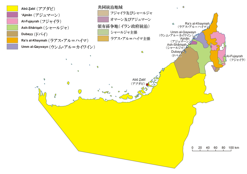
English: Administrative map of the United Arab Emirates in Japanese
日本語: アラブ首長国連邦の行政区分図(日本語) |
||||||||
| Date | |||||||||
| Source | File:UAE en-map.png。map of the United Arab Emirates published in Wielki Encyklopedyczny Atlas Świata (The Great Encyclopedian World Atlas), vol. 10 Azja Południowo-Zachodnia (Southwest Asia), Polish Scientific Publishers PWN, Warsaw 2006, p. 76-78 | ||||||||
| Author | Pqks758 (talk) | ||||||||
| Permission (Reusing this file) |
I, the copyright holder of this work, hereby publish it under the following license:
|
||||||||
| Other versions | File:ZEA pl-map.png、File:UAE en-map.png, File:VAE de-map.png (german) |

File history
Click on a date/time to view the file as it appeared at that time.
| Date/Time | Thumbnail | Dimensions | User | Comment | |
|---|---|---|---|---|---|
| current | 13:02, 16 March 2010 | | 1,600 × 1,130 (298 KB) | Pqks758 (talk | contribs) | {{Information |Description={{en|1=Administrative map of the United Arab Emirates in Japanese}} {{ja|1=アラブ首長国連邦の行政区分図(日本語)}} |Source=[[:File:UAE en-map.png] |
You cannot overwrite this file.
File usage on Commons
There are no pages that use this file.
File usage on other wikis
The following other wikis use this file:
- Usage on ja.wikipedia.org