File:View SSE over Port Eynon - geograph.org.uk - 1315435.jpg
Jump to navigation
Jump to search
No higher resolution available.
View_SSE_over_Port_Eynon_-_geograph.org.uk_-_1315435.jpg (640 × 480 pixels, file size: 77 KB, MIME type: image/jpeg)
Captions
Captions
Add a one-line explanation of what this file represents
Summary[edit]
| Description |
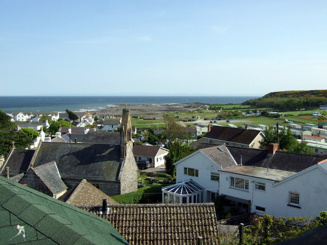
English: View SSE over Port Eynon The village is stacked up steeply behind the church and the higher levels afford splendid views. Here we are looking towards the rocky Sedgers bank and the headland beyond. Just visible is the remains of the Salt House dating from Port Eynon's days as a producer of salt; it was also an important oyster fishery once upon a time. |
| Date | |
| Source | From geograph.org.uk |
| Author | ceridwen |
| Attribution (required by the license) | ceridwen / View SSE over Port Eynon / |
| Camera location | | View this and other nearby images on: OpenStreetMap |
|---|
_heading:157.00&language=en)
| Object location | | View this and other nearby images on: OpenStreetMap |
|---|
_heading:157.00&language=en)
Licensing[edit]

|
This image was taken from the Geograph project collection. See this photograph's page on the Geograph website for the photographer's contact details. The copyright on this image is owned by ceridwen and is licensed for reuse under the Creative Commons Attribution-ShareAlike 2.0 license.
|
This file is licensed under the Creative Commons Attribution-Share Alike 2.0 Generic license.
Attribution: ceridwen
- You are free:
- to share – to copy, distribute and transmit the work
- to remix – to adapt the work
- Under the following conditions:
- attribution – You must give appropriate credit, provide a link to the license, and indicate if changes were made. You may do so in any reasonable manner, but not in any way that suggests the licensor endorses you or your use.
- share alike – If you remix, transform, or build upon the material, you must distribute your contributions under the same or compatible license as the original.
File history
Click on a date/time to view the file as it appeared at that time.
| Date/Time | Thumbnail | Dimensions | User | Comment | |
|---|---|---|---|---|---|
| current | 18:51, 27 February 2011 | | 640 × 480 (77 KB) | GeographBot (talk | contribs) | == {{int:filedesc}} == {{Information |description={{en|1=View SSE over Port Eynon The village is stacked up steeply behind the church and the higher levels afford splendid views. Here we are looking towards the rocky Sedgers bank and the headland beyond. |
You cannot overwrite this file.
File usage on Commons
There are no pages that use this file.