File:View from saana.JPG
Jump to navigation
Jump to search

Size of this preview: 800 × 533 pixels. Other resolutions: 320 × 213 pixels | 640 × 427 pixels | 1,024 × 683 pixels | 1,280 × 853 pixels | 2,976 × 1,984 pixels.
Original file (2,976 × 1,984 pixels, file size: 2.38 MB, MIME type: image/jpeg)
Captions
Captions
Add a one-line explanation of what this file represents
Summary[edit]
| Description |
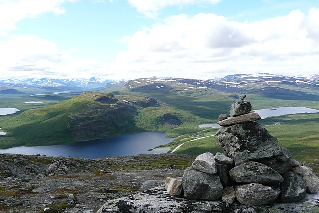
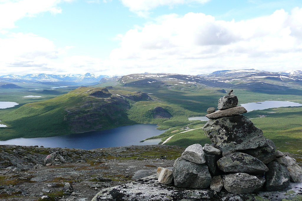
English: A view from Saana fell in the municipality of Enontekiö in Lapland, Finland. The stones on the right are one of the several stone stacks that the numerous visitors to Saana have gathered to the top of the fell. On the left a part of lake Kilpisjärvi is visible. The lake on the right is called Siilasjärvi. The closest fell in the picture is Pikku-Malla and behind that is Iso-Malla, both in the Malla Strict Nature Reserve.
Suomi: Näkymä Saanalta Enontekiön kunnassa Lapissa. Oikealla näkyvät kivet ovat yksi monista kivikasoista, jotka Saanan kävijät ovat koonneet tunturin huipulle. Vasemmalla kuvassa näkyy osa Kilpisjärvestä. Oikealla oleva järvi on Siilasjärvi. Lähin kuvassa oleva tunturi on Pikku-Malla ja sen takana on Iso-Malla, molemmat Mallan luonnonpuistossa. |
| Date | |
| Source | Own work |
| Author | Norppa |
| Camera location | | View this and other nearby images on: OpenStreetMap |
|---|
Accuracy of the camera location is about 100 m.
Licensing[edit]
I, the copyright holder of this work, hereby publish it under the following licenses:

|
Permission is granted to copy, distribute and/or modify this document under the terms of the GNU Free Documentation License, Version 1.2 or any later version published by the Free Software Foundation; with no Invariant Sections, no Front-Cover Texts, and no Back-Cover Texts. A copy of the license is included in the section entitled GNU Free Documentation License. |
This file is licensed under the Creative Commons Attribution 3.0 Unported license.
- You are free:
- to share – to copy, distribute and transmit the work
- to remix – to adapt the work
- Under the following conditions:
- attribution – You must give appropriate credit, provide a link to the license, and indicate if changes were made. You may do so in any reasonable manner, but not in any way that suggests the licensor endorses you or your use.
You may select the license of your choice.
File history
Click on a date/time to view the file as it appeared at that time.
| Date/Time | Thumbnail | Dimensions | User | Comment | |
|---|---|---|---|---|---|
| current | 12:03, 23 July 2008 | | 2,976 × 1,984 (2.38 MB) | Norppa (talk | contribs) | {{Information |Description={{en|1=A view from Saana fell in the municipality of Enontekiö in Lapland, Finland. The stones on the right are one of the several stone stacks that the numerous visitors to Saana have gathered to the top of the fell. On the le |
You cannot overwrite this file.
File usage on Commons
The following page uses this file:
File usage on other wikis
The following other wikis use this file:
- Usage on af.wikipedia.org
- Usage on bn.wiktionary.org
- Usage on ceb.wikipedia.org
- Usage on de.wikipedia.org
- Usage on en.wikipedia.org
- Usage on en.wikivoyage.org
- Usage on en.wiktionary.org
- Usage on es.wikipedia.org
- Usage on et.wikipedia.org
- Usage on eu.wikipedia.org
- Enontekiö
- Kilpisjärvi aintzira
- Mallako Natura Erreserba Hertsia
- Pöyrisjärvi (aintzira)
- Ounasjärvi
- Muotkajärvi aintzira
- Periläjärvi
- Enontekiöko babestutako eremuak
- Saana
- Ailakkajärvi
- Guoskatjávri
- Iso Salankijärvi
- Txantiloi:Enontekiö aintzirak
- Kelottijärvi aintzira
- Kalaton
- Kalatonjärvi
- Kaura
- Ketojärvi
- Lijankijärvi
- Kivijärvi aintzira
- Marsujärvi
- Marttajärvi
- Melajärvi
- Näkkäläjärvi
- Palojärvi aintzira
- Pasmajärvi (Enontekiö)
- Peltojärvi
- Somasjärvi
- Sotkajärvi
- Termisjärvi
- Tuolpajärvi
- Tuorkottajärvi
- Vuomajärvet
- Vuontisjärvi aintzira (Enontekiö)
- Iso Leveä
- Peerajärvi
- Ylimmäinen
View more global usage of this file.