File:WVjudicialcircuits.png
Jump to navigation
Jump to search

Size of this preview: 686 × 600 pixels. Other resolutions: 275 × 240 pixels | 549 × 480 pixels | 878 × 768 pixels | 1,171 × 1,024 pixels | 1,743 × 1,524 pixels.
Original file (1,743 × 1,524 pixels, file size: 87 KB, MIME type: image/png)
Captions
Captions
Add a one-line explanation of what this file represents
Summary[edit]
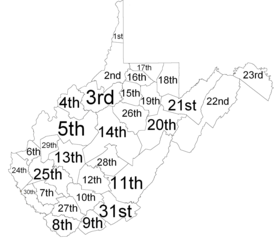
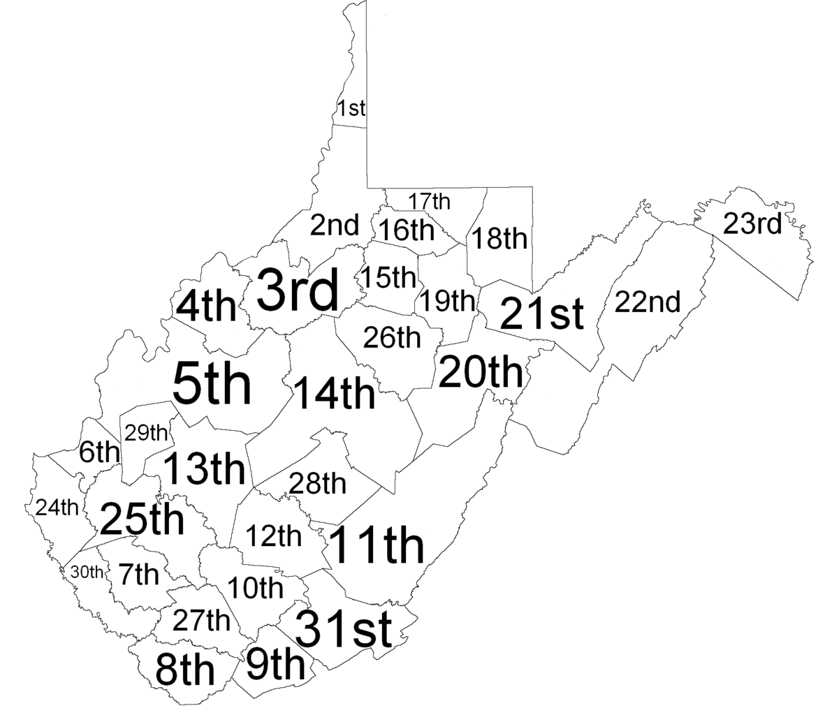
| Description | Map of West Virginia judicial circuits |
| Date | (UTC) |
| Source |
This file was derived from: West Virginia Counties.png: |
| Author |
|
| This is a retouched picture, which means that it has been digitally altered from its original version. Modifications: Removed lines and text, added numbers, cropped. The original can be viewed here: West Virginia Counties.png:
|
Licensing[edit]
I, the copyright holder of this work, hereby publish it under the following licenses:
| This file is licensed under the Creative Commons Attribution-Share Alike 3.0 Unported license. Subject to disclaimers. | ||
| ||
| This licensing tag was added to this file as part of the GFDL licensing update. |

|
Permission is granted to copy, distribute and/or modify this document under the terms of the GNU Free Documentation License, Version 1.2 or any later version published by the Free Software Foundation; with no Invariant Sections, no Front-Cover Texts, and no Back-Cover Texts. A copy of the license is included in the section entitled GNU Free Documentation License. Subject to disclaimers. |
You may select the license of your choice.
Original upload log[edit]
This image is a derivative work of the following images:
- File:West_Virginia_Counties.png licensed with Cc-by-sa-3.0-migrated-with-disclaimers, GFDL-en
- 2006-10-16T21:44:31Z JosN 776x599 (154669 Bytes) Map of West Virginia counties.
Uploaded with derivativeFX
File history
Click on a date/time to view the file as it appeared at that time.
| Date/Time | Thumbnail | Dimensions | User | Comment | |
|---|---|---|---|---|---|
| current | 12:55, 19 May 2012 | | 1,743 × 1,524 (87 KB) | Presidentman (talk | contribs) | == {{int:filedesc}} == {{Information |Description=Map of West Virginia judicial circuits |Source={{Derived from|West_Virginia_Counties.png|display=50}} |Date=2012-05-19 12:53 (UTC) |Author=*File:West_Virginia_Counties.png: Christian louis mcdonal... |
You cannot overwrite this file.
File usage on Commons
There are no pages that use this file.
File usage on other wikis
The following other wikis use this file:
- Usage on en.wikipedia.org