File:WW2 pillbox at Eckington bridge - geograph.org.uk - 759436.jpg
Jump to navigation
Jump to search
No higher resolution available.
WW2_pillbox_at_Eckington_bridge_-_geograph.org.uk_-_759436.jpg (640 × 426 pixels, file size: 102 KB, MIME type: image/jpeg)
Captions
Captions
Add a one-line explanation of what this file represents
Summary
[edit]
| Description |
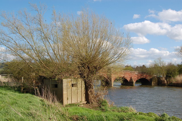
English: WW2 pillbox at Eckington bridge View looks eastwards and upstream towards Eckington bridge. In the foreground is a 'Stent' prefabricated pillbox that once defended the approaches to the bridge primarily from the far side of the river Avon (ie the south). In 1940 this pillbox formed part of one of the Midland stop-lines. Alas, the pillbox is slowly falling apart with evidence of recent flood damage. |
| Date | |
| Source | From geograph.org.uk |
| Author | Roger Davies |
| Attribution (required by the license) | Roger Davies / WW2 pillbox at Eckington bridge / |
| Camera location | | View this and other nearby images on: OpenStreetMap |
|---|
_heading:135.00&language=en)
| Object location | | View this and other nearby images on: OpenStreetMap |
|---|
_heading:135.00&language=en)
Licensing
[edit]

|
This image was taken from the Geograph project collection. See this photograph's page on the Geograph website for the photographer's contact details. The copyright on this image is owned by Roger Davies and is licensed for reuse under the Creative Commons Attribution-ShareAlike 2.0 license.
|
This file is licensed under the Creative Commons Attribution-Share Alike 2.0 Generic license.
Attribution: Roger Davies
- You are free:
- to share – to copy, distribute and transmit the work
- to remix – to adapt the work
- Under the following conditions:
- attribution – You must give appropriate credit, provide a link to the license, and indicate if changes were made. You may do so in any reasonable manner, but not in any way that suggests the licensor endorses you or your use.
- share alike – If you remix, transform, or build upon the material, you must distribute your contributions under the same or compatible license as the original.
File history
Click on a date/time to view the file as it appeared at that time.
| Date/Time | Thumbnail | Dimensions | User | Comment | |
|---|---|---|---|---|---|
| current | 16:44, 19 February 2011 | | 640 × 426 (102 KB) | GeographBot (talk | contribs) | == {{int:filedesc}} == {{Information |description={{en|1=WW2 pillbox at Eckington bridge View looks eastwards and upstream towards Eckington bridge. In the foreground is a 'Stent' prefabricated pillbox that once defended the approaches to the bridge prima |
You cannot overwrite this file.
File usage on Commons
There are no pages that use this file.