File:Wandel Sea map.png
Jump to navigation
Jump to search

Size of this preview: 600 × 600 pixels. Other resolutions: 240 × 240 pixels | 480 × 480 pixels | 768 × 768 pixels | 1,024 × 1,024 pixels | 2,000 × 2,000 pixels.
Original file (2,000 × 2,000 pixels, file size: 215 KB, MIME type: image/png)
Captions
Captions
Add a one-line explanation of what this file represents
Summary[edit]
| Description |
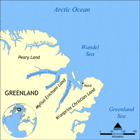
English: This map shows the location of the Wandel Sea northwest of Greenland and west of Svalbard. Nearby bodies of water include the Arctic Ocean, of which it is part, Greenland Sea, Lincoln Sea, Norwegian Sea, and Barents Sea. |
| Date | |
| Source | Own work |
| Author | NormanEinstein |
| Other versions | Derivative works of this file: Wandel Sea map de.png |
Licensing[edit]
I, the copyright holder of this work, hereby publish it under the following licenses:
This file is licensed under the Creative Commons Attribution-Share Alike 3.0 Unported license.
- You are free:
- to share – to copy, distribute and transmit the work
- to remix – to adapt the work
- Under the following conditions:
- attribution – You must give appropriate credit, provide a link to the license, and indicate if changes were made. You may do so in any reasonable manner, but not in any way that suggests the licensor endorses you or your use.
- share alike – If you remix, transform, or build upon the material, you must distribute your contributions under the same or compatible license as the original.

|
Permission is granted to copy, distribute and/or modify this document under the terms of the GNU Free Documentation License, Version 1.2 or any later version published by the Free Software Foundation; with no Invariant Sections, no Front-Cover Texts, and no Back-Cover Texts. A copy of the license is included in the section entitled GNU Free Documentation License. |
You may select the license of your choice.
File history
Click on a date/time to view the file as it appeared at that time.
| Date/Time | Thumbnail | Dimensions | User | Comment | |
|---|---|---|---|---|---|
| current | 14:52, 3 June 2015 | | 2,000 × 2,000 (215 KB) | Szczureq (talk | contribs) | Description correctly positioned |
| 15:44, 2 June 2015 |  | 2,000 × 2,000 (215 KB) | Szczureq (talk | contribs) | Description expanded with Mylius Erichsen Land | |
| 18:18, 4 May 2009 |  | 2,000 × 2,000 (213 KB) | NormanEinstein (talk | contribs) | Cropped map extent and added fjord names. | |
| 16:59, 27 January 2009 |  | 2,000 × 1,505 (370 KB) | NormanEinstein (talk | contribs) | {{Information |Description= |Source= |Date= |Author= |Permission= |other_versions= }} | |
| 20:42, 26 January 2009 |  | 1,500 × 1,129 (242 KB) | NormanEinstein (talk | contribs) | {{Information |Description={{en|1=This map shows the location of the Wandel Sea northwest of Greenland and west of Svalbard. Nearby bodies of water include the Arctic Ocean, of which it is part, Greenland Sea, Lincoln Sea, Norwegian Sea, and Barents Sea. |
You cannot overwrite this file.
File usage on Commons
The following 2 pages use this file:
File usage on other wikis
The following other wikis use this file:
- Usage on af.wikipedia.org
- Usage on ar.wikipedia.org
- Usage on ast.wikipedia.org
- Usage on azb.wikipedia.org
- Usage on az.wikipedia.org
- Usage on be-tarask.wikipedia.org
- Usage on be.wikipedia.org
- Usage on bs.wikipedia.org
- Usage on ca.wikipedia.org
- Usage on ceb.wikipedia.org
- Usage on ce.wikipedia.org
- Usage on cs.wikipedia.org
- Usage on cv.wikipedia.org
- Usage on da.wikipedia.org
- Usage on en.wikipedia.org
- Usage on en.wikiversity.org
- Usage on es.wikipedia.org
- Usage on eu.wikipedia.org
- Usage on fr.wikipedia.org
- Usage on he.wikipedia.org
- Usage on id.wikipedia.org
- Usage on ilo.wikipedia.org
- Usage on is.wikipedia.org
- Usage on it.wikipedia.org
- Usage on lt.wikipedia.org
- Usage on lv.wikipedia.org
- Usage on mk.wikipedia.org
- Usage on nl.wikipedia.org
- Usage on nn.wikipedia.org
- Usage on pa.wikipedia.org
- Usage on pl.wikipedia.org
- Usage on pnb.wikipedia.org
- Usage on pt.wikipedia.org
- Usage on ru.wikipedia.org
- Usage on sh.wikipedia.org
- Usage on sr.wikipedia.org
- Usage on sv.wikipedia.org
- Usage on tr.wikipedia.org
- Usage on uk.wikipedia.org
- Usage on ur.wikipedia.org
- Usage on vi.wikipedia.org
- Usage on war.wikipedia.org
- Usage on www.wikidata.org
View more global usage of this file.