File:Wayside shrine on Krautgartenweg in Matzendorf-Hölles.jpg
From Wikimedia Commons, the free media repository
Jump to navigation
Jump to search
Size of this preview: 400 × 600 pixels. Other resolutions: 160 × 240 pixels | 320 × 480 pixels | 512 × 768 pixels | 682 × 1,024 pixels | 1,365 × 2,048 pixels | 3,796 × 5,694 pixels.
Original file (3,796 × 5,694 pixels, file size: 6.73 MB, MIME type: image/jpeg)
File information
Structured data
Captions
Summary[edit]
DescriptionWayside shrine on Krautgartenweg in Matzendorf-Hölles.jpg |
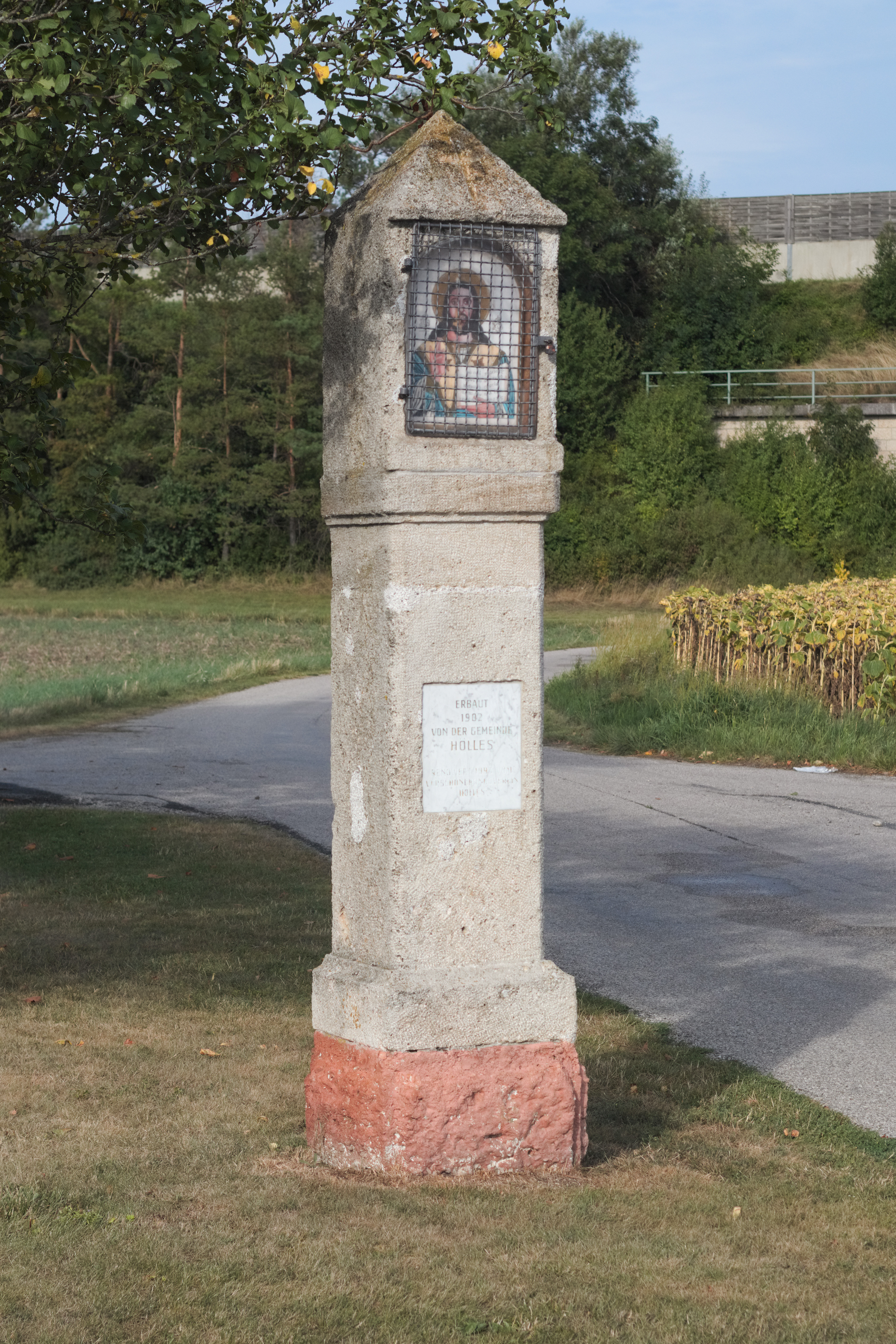
Deutsch: Einfacher Bildstock mit einer Christusikone am Krautgartenweg im Ortsteil Hölles von Matzendorf-Hölles, Niederösterreich, Österreich. |
Date | |
Source | Own work |
Author | Peter Wöhrer |
Camera location | 47° 53′ 53.49″ N, 16° 12′ 20.64″ E | View this and other nearby images on: OpenStreetMap | 47.898193; 16.205733 |
---|
Diese Datei wurde im Rahmen von WikiDaheim 2018 in Österreich erstellt und hochgeladen. Sie wurde dem allgemeinen Themenbereich zugeordnet. |
Licensing[edit]
I, the copyright holder of this work, hereby publish it under the following license:
This file is licensed under the Creative Commons Attribution-Share Alike 4.0 International license.
- You are free:
- to share – to copy, distribute and transmit the work
- to remix – to adapt the work
- Under the following conditions:
- attribution – You must give appropriate credit, provide a link to the license, and indicate if changes were made. You may do so in any reasonable manner, but not in any way that suggests the licensor endorses you or your use.
- share alike – If you remix, transform, or build upon the material, you must distribute your contributions under the same or compatible license as the original.
Diese Datei wurde im Rahmen von WikiDaheim 2018 in Österreich erstellt und hochgeladen. Sie wurde dem allgemeinen Themenbereich zugeordnet. |
File history
Click on a date/time to view the file as it appeared at that time.
Date/Time | Thumbnail | Dimensions | User | Comment | |
---|---|---|---|---|---|
current | 16:44, 14 August 2018 | 3,796 × 5,694 (6.73 MB) | Petwoe (talk | contribs) | User created page with UploadWizard |
You cannot overwrite this file.
File usage on Commons
The following page uses this file:
File usage on other wikis
The following other wikis use this file:
- Usage on de.wikipedia.org
- Usage on en.wikipedia.org
- Usage on www.wikidata.org
Metadata
This file contains additional information such as Exif metadata which may have been added by the digital camera, scanner, or software program used to create or digitize it. If the file has been modified from its original state, some details such as the timestamp may not fully reflect those of the original file. The timestamp is only as accurate as the clock in the camera, and it may be completely wrong.
Camera manufacturer | Canon |
---|---|
Camera model | Canon EOS M100 |
Exposure time | 1/1,600 sec (0.000625) |
F-number | f/5.6 |
ISO speed rating | 200 |
Date and time of data generation | 15:29, 14 August 2018 |
Lens focal length | 50 mm |
User comments | Einfacher Bildstock mit einer Christusikone am Krautgartenweg im Ortsteil Hölles von Matzendorf-Hölles, Niederösterreich, Österreich. |
Latitude | 47° 53′ 53.49″ N |
Longitude | 16° 12′ 20.64″ E |
Headline | Bildstock am Krautgartenweg in Matzendorf-Hölles, Niederösterreich |
Image title |
|
Width | 3,796 px |
Height | 5,694 px |
Bits per component | 8 |
Compression scheme | Uncompressed |
Orientation | Normal |
Number of components | 3 |
Horizontal resolution | 300 dpi |
Vertical resolution | 300 dpi |
Data arrangement | chunky format |
Software used | RawTherapee 5.2 |
File change date and time | 15:29, 14 August 2018 |
Exposure Program | Normal program |
Exif version | 2.3 |
Date and time of digitizing | 15:29, 14 August 2018 |
APEX shutter speed | 10.65625 |
APEX aperture | 4.96875 |
APEX exposure bias | 0 |
Metering mode | Pattern |
Flash | Flash did not fire, compulsory flash suppression |
DateTime subseconds | 46 |
DateTimeOriginal subseconds | 46 |
DateTimeDigitized subseconds | 46 |
Focal plane X resolution | 6,825.9385665529 |
Focal plane Y resolution | 6,825.9385665529 |
Focal plane resolution unit | inches |
Sensing method | One-chip color area sensor |
File source | Digital still camera |
Custom image processing | Normal process |
Exposure mode | Auto exposure |
White balance | Auto white balance |
Digital zoom ratio | 1 |
Scene capture type | Standard |
Geodetic survey data used | WGS-84 |
GPS tag version | 0.0.0.2 |
Structured data
Items portrayed in this file
depicts
14 August 2018
47°53'53.495"N, 16°12'20.639"E
0.000625 second
5.6
50 millimetre
200
image/jpeg
Hidden categories:
- Files with coordinates missing SDC location of creation
- Media from WikiDaheim 2018 in Austria/all
- Media from WikiDaheim 2018 in Austria/Unspecified
- CC-BY-SA-4.0
- Self-published work
- Media from WikiDaheim in Austria check done
- Uploaded via Campaign:WikiDaheim-at
- Austria photographs taken on 2018-08-14
- Pages with maps