File:Wbgz.svg

Original file (SVG file, nominally 587 × 732 pixels, file size: 709 KB)
Captions
Captions
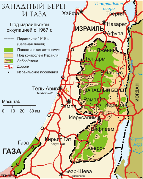
| DescriptionWbgz.svg | Карта оккупированных палестинских территорий |
| Date |
(UTC)
|
| Source | |
| Author |
This file is lacking author information.
|

|
This work is free software; you can redistribute it and/or modify it under the terms of the GNU General Public License as published by the Free Software Foundation; either version 2 of the License, or any later version. This work is distributed in the hope that it will be useful, but without any warranty; without even the implied warranty of merchantability or fitness for a particular purpose. See version 2 and version 3 of the GNU General Public License for more details.http://www.gnu.org/licenses/gpl.htmlGPLGNU General Public Licensetruetrue |
File history
Click on a date/time to view the file as it appeared at that time.
| Date/Time | Thumbnail | Dimensions | User | Comment | |
|---|---|---|---|---|---|
| current | 19:38, 19 January 2013 |  | 587 × 732 (709 KB) | Kaidor (talk | contribs) | Набулус → Наблус, озеро Кинерет → Тивериадское озеро. |
| 11:54, 9 August 2011 |  | 587 × 732 (778 KB) | Express2000 (talk | contribs) | {{Information |Description=Карта оккупированных палестинских территорий |Source=*File:West_Bank_&_Gaza_Map_2007_(Settlements).png |Date=2011-08-09 11:26 (UTC) *derivative work: ~~~ |Permission= |other_version | |
| 11:41, 9 August 2011 |  | 587 × 732 (779 KB) | Express2000 (talk | contribs) | {{Information |Description=Карта оккупированных палестинских территорий |Source=*File:West_Bank_&_Gaza_Map_2007_(Settlements).png |Date=2011-08-09 11:26 (UTC) *derivative work: ~~~ |Permission= |other_version |
You cannot overwrite this file.
File usage on Commons
The following page uses this file:
File usage on other wikis
The following other wikis use this file:
- Usage on be.wikipedia.org
- Usage on ky.wikipedia.org
- Usage on ru.wikipedia.org
Metadata
This file contains additional information such as Exif metadata which may have been added by the digital camera, scanner, or software program used to create or digitize it. If the file has been modified from its original state, some details such as the timestamp may not fully reflect those of the original file. The timestamp is only as accurate as the clock in the camera, and it may be completely wrong.
| Width | 165.784mm |
|---|---|
| Height | 206.679mm |