File:Western sahara walls moroccan map-ar.svg
Jump to navigation
Jump to search

Size of this PNG preview of this SVG file: 772 × 600 pixels. Other resolutions: 309 × 240 pixels | 618 × 480 pixels | 989 × 768 pixels | 1,280 × 994 pixels | 2,560 × 1,989 pixels | 1,676 × 1,302 pixels.
Original file (SVG file, nominally 1,676 × 1,302 pixels, file size: 187 KB)
Captions
Captions
Add a one-line explanation of what this file represents
Summary[edit]
| Description |
[]
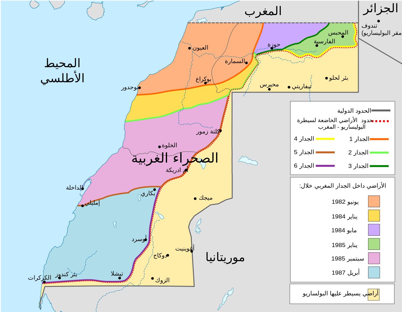
Deutsch: Karte des Marokkanischen Walls in der Westsahara. Er wurde in sechs Etappen in den 1980er Jahren errichtet, wie in der Karte dargestellt. Ebenfalls dargestellt ist das Polisario-Territorium und die Konfliktzone aus dem November 2020 (ermittelt anhand OSM). English: Map of the Moroccan Wall in Western Sahara - built over several stages, shows the six walls built, & when the territory was behind Moroccan wall. Also shows Polisario held territory who are based in Algeria (seen at top right). Euskara: Mendebaldeko Saharako harresien mapa العربية : خريطة الجدار الرملي المغربي في الصحراء الغربية |
||
| Date | |||
| Source | |||
| Author |
|
||
| Other versions |
[]
|


Licensing[edit]
I, the copyright holder of this work, hereby publish it under the following license:
This file is licensed under the Creative Commons Attribution-Share Alike 4.0 International license.
- You are free:
- to share – to copy, distribute and transmit the work
- to remix – to adapt the work
- Under the following conditions:
- attribution – You must give appropriate credit, provide a link to the license, and indicate if changes were made. You may do so in any reasonable manner, but not in any way that suggests the licensor endorses you or your use.
- share alike – If you remix, transform, or build upon the material, you must distribute your contributions under the same or compatible license as the original.
File history
Click on a date/time to view the file as it appeared at that time.
| Date/Time | Thumbnail | Dimensions | User | Comment | |
|---|---|---|---|---|---|
| current | 16:49, 4 March 2022 | | 1,676 × 1,302 (187 KB) | Nehaoua (talk | contribs) | تصحيح الازاحة |
| 16:43, 4 March 2022 |  | 1,676 × 1,302 (187 KB) | Nehaoua (talk | contribs) | تعريب المفتاح (مؤشر الألوان يكون على اليمين)+وضع أسماء المدن بالقرب من مواقعها | |
| 15:46, 4 March 2022 |  | 1,676 × 1,302 (195 KB) | Lolekek (talk | contribs) | Formatting | |
| 15:36, 4 March 2022 |  | 1,676 × 1,302 (195 KB) | Lolekek (talk | contribs) | Uploaded own work with UploadWizard |
You cannot overwrite this file.
File usage on Commons
The following 10 pages use this file:
- User:Lolekek/Uploads
- User:Magog the Ogre/Multilingual legend/2022 March 1-10
- File:Western sahara walls moroccan.png
- File:Western sahara walls moroccan map-ar.svg
- File:Western sahara walls moroccan map-de.svg
- File:Western sahara walls moroccan map-en.svg
- File:Western sahara walls moroccan map-es.svg
- File:Western sahara walls moroccan map-eu.svg
- File:Western sahara walls moroccan map-fr.svg
- Template:Other versions/Western Sahara walls map
File usage on other wikis
The following other wikis use this file:
- Usage on ar.wikipedia.org
- Usage on arz.wikipedia.org
- Usage on www.wikidata.org