File:Wisconsin WV region map EN.png
Jump to navigation
Jump to search

Size of this preview: 568 × 600 pixels. Other resolutions: 227 × 240 pixels | 455 × 480 pixels | 728 × 768 pixels | 970 × 1,024 pixels | 1,600 × 1,689 pixels.
Original file (1,600 × 1,689 pixels, file size: 565 KB, MIME type: image/png)
Captions
Captions
Add a one-line explanation of what this file represents
Summary[edit]
| Description |
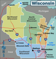
English: Wikivoyage style map of Wisconsin's travel regions. Red denotes Interstates and other divided highways; brown denotes other roads. |
| Date | |
| Source | Derivative work of File:Wisconsin regions map.svg. Additional road and lake boundaries based on data from Natural Earth. Interstate shields were sourced from File:US DOT FHWA MUTCD SHS 2004 3-1 M1-1 600x600mm 0.svg |
| Author | Original file by Peter Fitzgerald, derivative work by Shaundd |
| Other versions |
|
Licensing[edit]
I, the copyright holder of this work, hereby publish it under the following license:
This file is licensed under the Creative Commons Attribution-Share Alike 4.0 International license.
- You are free:
- to share – to copy, distribute and transmit the work
- to remix – to adapt the work
- Under the following conditions:
- attribution – You must give appropriate credit, provide a link to the license, and indicate if changes were made. You may do so in any reasonable manner, but not in any way that suggests the licensor endorses you or your use.
- share alike – If you remix, transform, or build upon the material, you must distribute your contributions under the same or compatible license as the original.
File history
Click on a date/time to view the file as it appeared at that time.
| Date/Time | Thumbnail | Dimensions | User | Comment | |
|---|---|---|---|---|---|
| current | 05:15, 29 October 2015 | | 1,600 × 1,689 (565 KB) | Shaundd (talk | contribs) | User created page with UploadWizard |
You cannot overwrite this file.
File usage on Commons
There are no pages that use this file.
File usage on other wikis
The following other wikis use this file: