File:World+60.svg
Jump to navigation
Jump to search

Size of this PNG preview of this SVG file: 798 × 97 pixels. Other resolutions: 320 × 39 pixels | 640 × 78 pixels | 1,024 × 125 pixels | 1,280 × 156 pixels | 2,560 × 311 pixels | 13,153 × 1,600 pixels.
Original file (SVG file, nominally 13,153 × 1,600 pixels, file size: 1.88 MB)
Captions
Captions
Add a one-line explanation of what this file represents
Summary
[edit]
| Description |
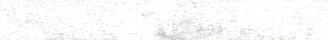
English: Map of the region between 50° and 70° northern latitude. SVG-version without background. Scale: 1527 m/pixel at 60° latitude (1962 m/pixel at 50° latitude, 1045 m/pixel at 70° latitude). Projection: WGS 84 / Pseudo Mercator, EPSG: 3857. Extent (xmin, ymin, xmax, ymax): -20036395.150 -6336811.491 20036395.150 11211532.855.
Legend: motorway
primary road
secondary road
railway
ferry line
communications cable
border
plate-boundary
water
river/canal
wetland
archeological site, point of interest
power, industrial
people |
| Date | |
| Source | Own work + Openstreetmap, Wikipedia articles, Wikivoyage articles, http://openstreetmapdata.com, http://www.naturalearthdata.com, Tiger https://www.census.gov/cgi-bin/geo/shapefiles/index.php, CanVec http://geogratis.gc.ca/geogratis/en/search, http://www.env.gov.yk.ca/maps/view/detail/1/33/429, https://pubs.usgs.gov/of/2014/1040/ undersea features, http://www.cablemap.info/ communications cables data, Mapbox Satellite, https://www.lib.utexas.edu/maps/commonwealth/ussr_terrain_1974.jpg |
| Author | Metropolcarte |
| Other versions | File:World+60.jpg, File:World+60blankroads.jpg |
Licensing
[edit]
I, the copyright holder of this work, hereby publish it under the following license:
This file is licensed under the Creative Commons Attribution-Share Alike 4.0 International license.
- You are free:
- to share – to copy, distribute and transmit the work
- to remix – to adapt the work
- Under the following conditions:
- attribution – You must give appropriate credit, provide a link to the license, and indicate if changes were made. You may do so in any reasonable manner, but not in any way that suggests the licensor endorses you or your use.
- share alike – If you remix, transform, or build upon the material, you must distribute your contributions under the same or compatible license as the original.
| This work contains information from OpenStreetMap, which is made available under the Open Database License (ODbL).
The ODbL does not require any particular license for maps produced from ODbL data. Prior to 1 August 2020, map tiles produced by the OpenStreetMap Foundation were licensed under the CC-BY-SA-2.0 license. Maps produced by other people may be subject to other licences. |
Canada hydrography: http://open.canada.ca/en/open-government-licence-canada, communications cables data: Greg's Cable Map GPL v3
File history
Click on a date/time to view the file as it appeared at that time.
| Date/Time | Thumbnail | Dimensions | User | Comment | |
|---|---|---|---|---|---|
| current | 21:16, 4 June 2017 | 13,153 × 1,600 (1.88 MB) | Metropolcarte (talk | contribs) | User created page with UploadWizard |
You cannot overwrite this file.
File usage on Commons
There are no pages that use this file.