File:Yorii, CKT951X-C2-11.jpg
Jump to navigation
Jump to search

Size of this preview: 662 × 599 pixels. Other resolutions: 265 × 240 pixels | 530 × 480 pixels | 848 × 768 pixels | 1,131 × 1,024 pixels | 2,262 × 2,048 pixels | 3,552 × 3,216 pixels.
Original file (3,552 × 3,216 pixels, file size: 4.33 MB, MIME type: image/jpeg)
Captions
Captions
Add a one-line explanation of what this file represents
Summary[edit]
| Description |
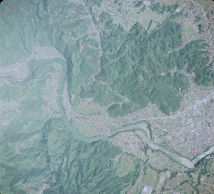
日本語: 埼玉県大里郡寄居町付近の航空写真。
English: An aerial photo of Yorii town, Saitama pref., Japan. |
| Date | |
| Source |
日本語: 国土画像情報(カラー空中写真)(整理番号:CKT951X、コース番号:C2、写真番号:11、撮影年月日:1995年5月18日、撮影地域:大宮、撮影高度:3820m、撮影縮尺:1/25000、カメラ名称:RC20、焦点距離:153.530mm、カラー種別:カラー、写真種別:アナログ、撮影計画機関:国土地理院、市区町村名:大里郡寄居町)http://mapps.gsi.go.jp/contentsImageDisplay.do?specificationId=766286&isDetail=false
English: National Land Image Information (Color Aerial Photographs) (Reference number: CKT951X; Course Number: C2; Photo Number: 11; Date: May 18, 1995; Area: Omiya; Height: 3820 metre; Scale: 1/25000; Camera Name: RC20; Focal Distance: 153.050 millimetre; Color Type: Color; Photo Type: Analog; Agency: Geographical Survey Institute of Japan; Municipality: Yorii Town, Ōsato District) https://mapps.gsi.go.jp/contentsImageDisplay.do?specificationId=107650&isDetail=false |
| Author |
English: Geographical Survey Institute of Japan 日本語: 国土地理院 |
Licensing[edit]

|
The copyright holder of this file, Ministry of Land, Infrastructure, Transport and Tourism, allows anyone to use it for any purpose, provided that the copyright holder is properly attributed. Redistribution, derivative work, commercial use, and all other use is permitted. |
Attribution:
National Land Image Information (Color Aerial Photographs), created by Ministry of Land, Infrastructure, Transport and Tourism, distributed by Geospatial Information Authority of Japan
|

File history
Click on a date/time to view the file as it appeared at that time.
| Date/Time | Thumbnail | Dimensions | User | Comment | |
|---|---|---|---|---|---|
| current | 23:47, 8 August 2020 | | 3,552 × 3,216 (4.33 MB) | Miyuki Meinaka (talk | contribs) | Uploaded a work by {{en|1=Geographical Survey Institute of Japan}}{{ja|1=国土地理院}} from {{ja|1=国土画像情報(カラー空中写真)(整理番号:CKT951X、コース番号:C2、写真番号:11、撮影年月日:1995年5月18日、撮影地域:大宮、撮影高度:3820m、撮影縮尺:1/25000、カメラ名称:RC20、焦点距離:153.530mm、カラー種別:カラー、写真種別:アナログ、撮影計画機関:国土地理院、市区町村名:大里郡寄居町)http://mapps.gsi.go.jp/contentsImageDisplay.do?specificationId=766286&isDetail=false}} {{en|1=National Land Image Information (Color Aerial Photographs) (Reference number: CKT951X; Course Number: C2; Photo Number: 11; Date:... |
You cannot overwrite this file.
File usage on Commons
There are no pages that use this file.
File usage on other wikis
The following other wikis use this file:
- Usage on ja.wikipedia.org