File:Zachodniopomorskie mapa fizyczna.png
Jump to navigation
Jump to search

Size of this preview: 561 × 599 pixels. Other resolutions: 225 × 240 pixels | 449 × 480 pixels | 719 × 768 pixels | 959 × 1,024 pixels | 2,314 × 2,472 pixels.
Original file (2,314 × 2,472 pixels, file size: 801 KB, MIME type: image/png)
Captions
Captions
Add a one-line explanation of what this file represents
Summary
[edit]| Description |
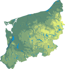
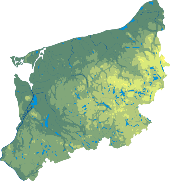
Polski: Mapa wód i ukształtowania powierzchni województwa zachodniopomorskiego. Autor: Aotearoa Współrzędne graniczne mapy:
Legenda  |
| Date | 29 August 2006 (original upload date) |
| Source | Transferred from pl.wikipedia to Commons by Pjahr using CommonsHelper. |
| Author | Aotearoa at Polish Wikipedia |
| Other versions |
|

Licensing
[edit]
Aotearoa at Polish Wikipedia, the copyright holder of this work, hereby publishes it under the following license:

|
Permission is granted to copy, distribute and/or modify this document under the terms of the GNU Free Documentation License, Version 1.2 or any later version published by the Free Software Foundation; with no Invariant Sections, no Front-Cover Texts, and no Back-Cover Texts. A copy of the license is included in the section entitled GNU Free Documentation License. |
| This file is licensed under the Creative Commons Attribution-Share Alike 3.0 Unported license. | ||
| Attribution: Aotearoa at Polish Wikipedia | ||
| ||
| This licensing tag was added to this file as part of the GFDL licensing update. |
Original upload log
[edit]
The original description page was here. All following user names refer to pl.wikipedia.
- 2006-08-29 18:35 Aotearoa 481×512× (105253 bytes) Mapa wód i ukształtowania powierzchni województwa zachodniopomorskiego. Autor: [[Wikipedysta:Aotearoa|Aotearoa]]
File history
Click on a date/time to view the file as it appeared at that time.
| Date/Time | Thumbnail | Dimensions | User | Comment | |
|---|---|---|---|---|---|
| current | 11:06, 29 October 2012 | | 2,314 × 2,472 (801 KB) | Aotearoa (talk | contribs) | drobne techniczne |
| 18:30, 5 December 2009 |  | 481 × 512 (103 KB) | File Upload Bot (Magnus Manske) (talk | contribs) | {{BotMoveToCommons|pl.wikipedia|year={{subst:CURRENTYEAR}}|month={{subst:CURRENTMONTHNAME}}|day={{subst:CURRENTDAY}}}} {{Information |Description={{pl|Mapa wód i ukształtowania powierzchni województwa zachodniopomorskiego. Autor: [[:pl:Wikipedysta:Aot |
You cannot overwrite this file.
File usage on Commons
The following page uses this file:
File usage on other wikis
The following other wikis use this file:
- Usage on be.wikipedia.org
- Usage on bg.wikipedia.org
- Шчечин
- Старгард
- Швиноуйшче
- Колобжег
- Пшибоже (Западнопоморско войводство)
- Лобжани
- Тшешчина
- Кошалин
- Грифино
- Грифице
- Шчечинек
- Полице
- Валч
- Бялогард
- Голеньов
- Гошчино
- Дравско Поморске
- Камен Поморски
- Лобез
- Мишлибож
- Пижице
- Славно
- Хошчно
- Швидвин
- Новогард
- Барлинек
- Шаблон:ПК Полша Западнопоморско войводство
- Радзанек
- Дравско (езеро)
- Долуйе
- Лович Валецки
- Битка при Цединя
- Славобоже
- Usage on ce.wikipedia.org
- Usage on de.wikipedia.org
- Usage on eo.wikipedia.org
- Usage on es.wikipedia.org
- Usage on fr.wikipedia.org
- Usage on lv.wikipedia.org
View more global usage of this file.