File:Zungeni map.png

Original file (1,166 × 791 pixels, file size: 1.94 MB, MIME type: image/png)
Captions
Captions
Summary
[edit]
| Description |
English: Military Map of Zulu Land, 1879 |
| Date |
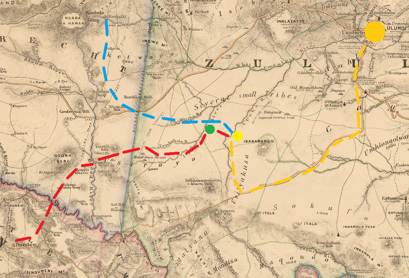
Movements of the British 2nd Division (red) and Wood's flying column (blue) to Zungeni Mountain (yellow). Fort Newdigate shown in green and onwards movement to Ulundi in orange |
| Source |
This file was derived from: Military Map of Zulu Land.jpg: |
| Author |
|
| This is a retouched picture, which means that it has been digitally altered from its original version. Modifications: cropped to Zunegni Mountain area, British movements noted. The original can be viewed here: Military Map of Zulu Land.jpg:
|
Licensing
[edit]
Base file:
|
This work is in the public domain in its country of origin and other countries and areas where the copyright term is the author's life plus 70 years or fewer. This work is in the public domain in the United States because it was published (or registered with the U.S. Copyright Office) before January 1, 1929. | |
| This file has been identified as being free of known restrictions under copyright law, including all related and neighboring rights. | |
Additions by Dumelow:
| I, the copyright holder of this work, release this work into the public domain. This applies worldwide. In some countries this may not be legally possible; if so: I grant anyone the right to use this work for any purpose, without any conditions, unless such conditions are required by law. |
Original upload log
[edit]
This image is a derivative work of the following images:
- File:Military Map of Zulu Land.jpg licensed with PD-old-70-expired
- 2019-12-03T19:56:53Z Hohum 2307x1700 (4701679 Bytes) User created page with UploadWizard
Uploaded with derivativeFX
File history
Click on a date/time to view the file as it appeared at that time.
| Date/Time | Thumbnail | Dimensions | User | Comment | |
|---|---|---|---|---|---|
| current | 17:35, 6 January 2022 | | 1,166 × 791 (1.94 MB) | Dumelow (talk | contribs) | == {{int:filedesc}} == {{Information |Description={{en|1=Military Map of Zulu Land, 1879}} |date=1879-05-21 Movements of the British 2nd Division (red) and Wood's flying column (blue) to Zungeni Mountain (yellow). Fort Newdigate shown in green and onwards movement to Ulundi in orange |Source={{Derived from|Military Map of Zulu Land.jpg|display=50}} |Date=2022-01-06 17:34 (UTC) |Author=* File:Military Map of Zulu Land.jpg: Intelligence Branch of the Qu... |
You cannot overwrite this file.
File usage on Commons
There are no pages that use this file.
File usage on other wikis
The following other wikis use this file:
- Usage on en.wikipedia.org