File:Ög105 Kärna kyrka - KMB - 16000300028189.jpg
Jump to navigation
Jump to search

Size of this preview: 400 × 600 pixels. Other resolutions: 160 × 240 pixels | 512 × 768 pixels.
Original file (512 × 768 pixels, file size: 166 KB, MIME type: image/jpeg)
Captions
Captions
Add a one-line explanation of what this file represents
| Ög105 Kärna kyrka
( |
|||||||||||||||||||||||||||
|---|---|---|---|---|---|---|---|---|---|---|---|---|---|---|---|---|---|---|---|---|---|---|---|---|---|---|---|
| Photographer |
|
||||||||||||||||||||||||||
| Title |
Ög105 Kärna kyrka |
||||||||||||||||||||||||||
| Original caption |
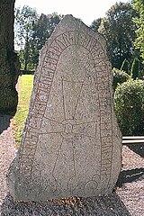
Notera Av dokumentationsskäl har originalbeskrivningen från Riksantikvarieämbetet behållits. Tillrättalägganden och alternativa beskrivningar bör införas separat från nedanstående information. Inskriften lyder: Torsten reste stenen efter Viste, sin fader, en duktig bonde, som var son till Gise.Felaktigheter kan även anmälas till denna sida. Motiv: Ög105 Kärna kyrka |
||||||||||||||||||||||||||
| Description |
Inskriften lyder: Torsten reste stenen efter Viste, sin fader, en duktig bonde, som var son till Gise.
|
||||||||||||||||||||||||||
| Depicted place | Sweden, Linköping Municipality, Q10551860 | ||||||||||||||||||||||||||
| Date | 18 September 2000 | ||||||||||||||||||||||||||
| Collection |
|
||||||||||||||||||||||||||
| Accession number | |||||||||||||||||||||||||||
| Source |
Bengt A Lundberg / Kulturmiljöbild, Riksantikvarieämbetet
|
||||||||||||||||||||||||||
| Permission (Reusing this file) |
This file is licensed under the Creative Commons Attribution 2.5 Generic license. Attribution: Bengt A Lundberg / Riksantikvarieämbetet
|
||||||||||||||||||||||||||


| Object location | | View this and other nearby images on: OpenStreetMap |
|---|
File history
Click on a date/time to view the file as it appeared at that time.
| Date/Time | Thumbnail | Dimensions | User | Comment | |
|---|---|---|---|---|---|
| current | 20:06, 9 June 2017 | | 512 × 768 (166 KB) | AndreCostaWMSE-bot (talk | contribs) | {{Kulturmiljöbild-image | short title = Ög105 Kärna kyrka | original description = Inskriften lyder: Torsten reste stenen efter Viste, sin fader, en duktig bonde, som var son till Gise.<br> Motiv: Ög105 Kärna kyrka<br> Nyckelord: Runor<br> Kategor... |
You cannot overwrite this file.
File usage on Commons
The following 2 pages use this file:
File usage on other wikis
The following other wikis use this file: