File:Уральская область 1900.svg
Jump to navigation
Jump to search

Size of this PNG preview of this SVG file: 505 × 600 pixels. Other resolutions: 202 × 240 pixels | 404 × 480 pixels | 647 × 768 pixels | 862 × 1,024 pixels | 1,725 × 2,048 pixels | 539 × 640 pixels.
Original file (SVG file, nominally 539 × 640 pixels, file size: 33 KB)
Captions
Captions
Add a one-line explanation of what this file represents
Summary
[edit]
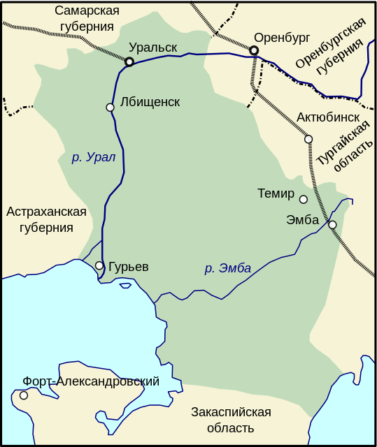
| Description | Уральская область с 1868 по 1932 годы. |
| Date | 7 December 2006 (original upload date) |
| Source | No machine-readable source provided. Own work assumed (based on copyright claims). |
| Author | No machine-readable author provided. Wassily assumed (based on copyright claims). |
| Other versions |
|
Licensing
[edit]
I, the copyright holder of this work, hereby publish it under the following license:

|
Permission is granted to copy, distribute and/or modify this document under the terms of the GNU Free Documentation License, Version 1.2 or any later version published by the Free Software Foundation; with no Invariant Sections, no Front-Cover Texts, and no Back-Cover Texts. A copy of the license is included in the section entitled GNU Free Documentation License. |
| This file is licensed under the Creative Commons Attribution-Share Alike 3.0 Unported license. | ||
| ||
| This licensing tag was added to this file as part of the GFDL licensing update. |
File history
Click on a date/time to view the file as it appeared at that time.
| Date/Time | Thumbnail | Dimensions | User | Comment | |
|---|---|---|---|---|---|
| current | 12:43, 18 May 2014 | | 539 × 640 (33 KB) | Geoalex (talk | contribs) | Reverted to version as of 12:21, 30 October 2007 |
| 16:05, 28 March 2014 |  | 512 × 608 (9 KB) | Vyacheslav Nasretdinov (talk | contribs) | Cleaning of code | |
| 12:21, 30 October 2007 |  | 539 × 640 (33 KB) | WarXboT (talk | contribs) | minor fixes | |
| 19:12, 7 December 2006 |  | 179 × 212 (32 KB) | Wassily (talk | contribs) | Уральская область с 1868 по 1932 годы. Category:SVG карты на русском Category:Maps of Kazakhstan Category:Historical maps of the empire of Russia {{self|GFDL}} |
You cannot overwrite this file.
File usage on Commons
The following 2 pages use this file:
File usage on other wikis
The following other wikis use this file:
- Usage on ar.wikipedia.org
- Usage on ba.wikipedia.org
- Usage on cv.wikipedia.org
- Usage on ja.wikipedia.org
- Usage on kk.wikipedia.org
- Usage on ko.wikipedia.org
- Usage on nl.wikipedia.org
- Usage on pl.wikipedia.org
- Usage on ru.wikipedia.org
- Usage on tr.wikipedia.org
- Usage on tt.wikipedia.org
- Usage on uk.wikipedia.org
- Usage on www.wikidata.org
- Usage on xmf.wikipedia.org
- Usage on zh.wikipedia.org