File:Banks Peninsula from space.jpg
- Fichier
- Historique du fichier
- Utilisations locales du fichier
- Utilisations du fichier sur d’autres wikis
- Métadonnées
Banks_Peninsula_from_space.jpg (300 × 279 pixels, taille du fichier : 19 kio, type MIME : image/jpeg)
Légendes
Légendes
Description[modifier]
from en wikipedia
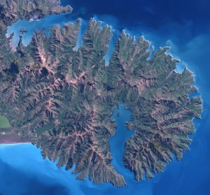
This shows Banks Peninsula, including Lyttelton Harbour and Akaroa Harbour, in Canterbury, New Zealand.
This image was acquired by the Enhanced Thematic Mapper plus (ETM+) sensor flying aboard the Landsat 7 satellite on September 25, 2001.
Image courtesy Jacques Descloitres, MODIS Land Rapid Response Team at NASA GSFC.
SOURCE: Large image copie d'archive sur Wayback Machine from NASA Earth Observatory
”The purpose of NASA's Earth Observatory is to provide a freely-accessible publication on the Internet where the public can obtain new satellite imagery and scientific information about our home planet. The focus is on Earth's climate and environmental change. In particular, we hope our site is useful to public media and educators. Any and all materials published on the Earth Observatory are freely available for re-publication or re-use, except where copyright is indicated. We ask that NASA's Earth Observatory be given credit for its original materials.”
| Public domainPublic domainfalsefalse |
| Ce fichier provient de la NASA. Sauf exception, les documents créés par la NASA ne sont pas soumis à copyright. Pour plus d'informations, voir la politique de copyright de la NASA. |  | |
 |
Attention :
|
Historique du fichier
Cliquer sur une date et heure pour voir le fichier tel qu'il était à ce moment-là.
| Date et heure | Vignette | Dimensions | Utilisateur | Commentaire | |
|---|---|---|---|---|---|
| actuel | 19 juillet 2005 à 22:34 |  | 300 × 279 (19 kio) | Matanya (usurped) (d | contributions) | from en wikipedia This shows Banks Peninsula, including Lyttelton Harbour and Akaroa Harbour, in Canterbury, New Zealand. This image was acquired by the Enhanced Thematic Mapper plus (ETM+) sensor flying aboar |
Vous ne pouvez pas remplacer ce fichier.
Utilisations locales du fichier
Les 3 pages suivantes utilisent ce fichier :
Utilisations du fichier sur d’autres wikis
Les autres wikis suivants utilisent ce fichier :
- Utilisation sur an.wikipedia.org
- Utilisation sur az.wikipedia.org
- Utilisation sur ceb.wikipedia.org
- Utilisation sur de.wikipedia.org
- Utilisation sur en.wikipedia.org
- Utilisation sur en.wikivoyage.org
- Utilisation sur en.wiktionary.org
- Utilisation sur eo.wikipedia.org
- Utilisation sur es.wikipedia.org
- Utilisation sur fi.wikipedia.org
- Utilisation sur fr.wikipedia.org
- Utilisation sur fr.wikivoyage.org
- Utilisation sur he.wikipedia.org
- Utilisation sur he.wiktionary.org
- Utilisation sur it.wikipedia.org
- Utilisation sur ja.wikipedia.org
- Utilisation sur ko.wikipedia.org
- Utilisation sur nl.wikipedia.org
- Utilisation sur nn.wikipedia.org
- Utilisation sur no.wikipedia.org
- Utilisation sur pt.wikipedia.org
- Utilisation sur ru.wikipedia.org
- Utilisation sur sl.wikipedia.org
- Utilisation sur uk.wikipedia.org
- Utilisation sur www.wikidata.org
- Utilisation sur zh.wikipedia.org
- Utilisation sur zh.wiktionary.org
Métadonnées
Ce fichier contient des informations supplémentaires, probablement ajoutées par l'appareil photo numérique ou le numériseur utilisé pour le créer.
Si le fichier a été modifié depuis son état original, certains détails peuvent ne pas refléter entièrement l'image modifiée.
| _error | 0 |
|---|
