File:Bolivia satellite deforestation 1986 2001.jpg
Bolivia_satellite_deforestation_1986_2001.jpg (540 × 448 pixels, taille du fichier : 103 kio, type MIME : image/jpeg)
Légendes
Légendes
Description[modifier]
| Description |
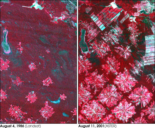
Deforestation in Santa Cruz, Bolivia. From Earth Observatory : "These images from 1986 and 2001 are for an area of tropical dry forest lying east of Santa Cruz de la Sierra, Bolivia. Since the mid-1980s, the resettlement of people from the Altiplano (the Andean high plains) and a large agricultural development effort (the Tierras Baja project) has lead to this area’s deforestation. Soybean production began in earnest in the early 1970s following a substantial increase in the crop’s world price. The pie or radial patterned fields are part of the San Javier resettlement scheme. At the center of each unit is a small community that includes a church, bar/café, school, and soccer field. The rectangular, light colored areas are fields of soybeans cultivated for export, mostly funded by foreign loans. The dark strips running through the fields are windbreaks, which are advantageous because the soils in this area are fine and prone to wind erosion. The 1986 Landsat image (left) was acquired on August 4, 1986, and the ASTER image (right) on August 11, 2001." Image courtesy NASA/GSFC/MITI/ERSDAC/JAROS, and U.S./Japan ASTER Science Team Any and all materials published on the Earth Observatory are freely available for re-publication or re-use, except where copyright is indicated. We ask that NASA's Earth Observatory be given credit for its original materials. |
| Source | NASA |
| Auteur | NASA |
Conditions d’utilisation[modifier]
| Ce fichier provient de la NASA. Sauf exception, les documents créés par la NASA ne sont pas soumis à copyright. Pour plus d'informations, voir la politique de copyright de la NASA. | ||
 |
Attention :
|
Journal des téléversements d’origine[modifier]
- 2005-08-07 18:21 Delorme 540×448×8 (105607 bytes) Deforestation in Santa Cruz, Bolivia. From [[Earth Observatory |http://earthobservatory.nasa.gov/Newsroom/NewImages/images.php3?img_id=16274]] "These images from 1986 and 2001 are for an area of tropical dry forest lying east of Santa Cruz de la Sierra
Historique du fichier
Cliquer sur une date et heure pour voir le fichier tel qu'il était à ce moment-là.
| Date et heure | Vignette | Dimensions | Utilisateur | Commentaire | |
|---|---|---|---|---|---|
| actuel | 3 janvier 2007 à 17:58 | | 540 × 448 (103 kio) | Frog Bot (d | contributions) | semi-automatic upload by user:bayo from fr.wikipedia.org "Image:Bolivia satellite deforestation 1986 2001 .jpg" |
Vous ne pouvez pas remplacer ce fichier.
Utilisations locales du fichier
La page suivante utilise ce fichier :
- File:Bolivia satellite deforestation 1986 2001 .jpg (redirection de fichier)
Utilisations du fichier sur d’autres wikis
Les autres wikis suivants utilisent ce fichier :
- Utilisation sur fr.wikipedia.org
- Utilisation sur it.wikipedia.org
- Utilisation sur no.wikipedia.org