File:Cautethia grotei MHNT CUT 2010 0 254 Florida City, Florida, male.jpg
Jump to navigation
Jump to search

Size of this preview: 523 × 599 pixels. Other resolutions: 209 × 240 pixels | 419 × 480 pixels | 670 × 768 pixels | 894 × 1,024 pixels | 1,788 × 2,048 pixels | 7,376 × 8,448 pixels.
Original file (7,376 × 8,448 pixels, file size: 22.94 MB, MIME type: image/jpeg)
Captions
Captions
Add a one-line explanation of what this file represents
|
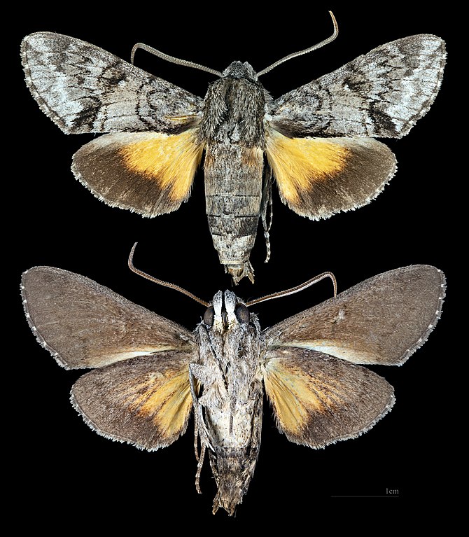
Cautethia grotei H. Edwards, 1882 |
| Photographer | ||||||||||||||||||||||||
| Description |
Deutsch: Cautethia grotei - Zwei Ansichten des gleichen Exemplars
English: Cautethia grotei - Two views of same specimen
Français : Cautethia grotei - Deux vues du même spécimen
|
|||||||||||||||||||||||
| Gender | Male | |||||||||||||||||||||||
| Place of discovery | Deutsch: Florida City, Florida, Vereinigte Staaten English: Florida City, Florida USA Français : Florida City, Floride Etats Unis d’Amérique |
|||||||||||||||||||||||
| Date | Taken on 2 August 2018 | |||||||||||||||||||||||
| Collection |
|
|||||||||||||||||||||||
| Accession number |
MHNT Cut 2010 0 254 |
|||||||||||||||||||||||
| Source | Own work | |||||||||||||||||||||||
| Permission (Reusing this file) |
I, the copyright holder of this work, hereby publish it under the following license: This file is licensed under the Creative Commons Attribution-Share Alike 4.0 International license.
|
|||||||||||||||||||||||
| Other versions |
| |||||||||||||||||||||||
| Processing | Focus stacking of 4 pictures. | |||||||||||||||||||||||


| Camera location | | View this and other nearby images on: OpenStreetMap |
|---|

|
This document was made as part of the Projet Phoebus.
|
File history
Click on a date/time to view the file as it appeared at that time.
| Date/Time | Thumbnail | Dimensions | User | Comment | |
|---|---|---|---|---|---|
| current | 13:05, 11 August 2018 | | 7,376 × 8,448 (22.94 MB) | Archaeodontosaurus (talk | contribs) | {{Information |description ={{en|1=df}} |date = |source ={{own}} |author =User:Archaeodontosaurus }} |
You cannot overwrite this file.
File usage on Commons
The following 7 pages use this file:
- Cautethia grotei
- User:DCB/Landkreis Görlitz/2018 August 11-20
- User:Paris 16/Recent uploads/2018 August 11-13
- File:Cautethia grotei MHNT CUT 2010 0 254 Florida City, Florida, male.jpg
- File:Cautethia grotei MHNT CUT 2010 0 254 Florida City, Florida, male dorsal.jpg
- File:Cautethia grotei MHNT CUT 2010 0 254 Florida City, Florida, male ventral.jpg
- Category:Cautethia grotei
File usage on other wikis
The following other wikis use this file:
- Usage on de.wikipedia.org
- Usage on en.wikipedia.org
- Usage on fr.wikipedia.org
- Usage on it.wikipedia.org
- Usage on no.wikipedia.org
- Usage on ro.wikipedia.org
- Usage on species.wikimedia.org
- Usage on sv.wikipedia.org
- Usage on vi.wikipedia.org
- Usage on war.wikipedia.org
- Usage on www.wikidata.org