File:Chesapeake and Ohio Canal National Historical Park (map).jpg
Jump to navigation
Jump to search

Size of this preview: 226 × 598 pixels. Other resolutions: 90 × 240 pixels | 181 × 480 pixels | 290 × 768 pixels | 387 × 1,024 pixels | 774 × 2,048 pixels | 2,740 × 7,248 pixels.
Original file (2,740 × 7,248 pixels, file size: 6.8 MB, MIME type: image/jpeg)
Captions
Captions
Add a one-line explanation of what this file represents
Summary
[edit].jpg&action=edit§ion=1)

|
File:Chesapeake and Ohio Canal National Historical Park (map).svg is a vector version of this file. It should be used in place of this JPG file when not inferior.
File:Chesapeake and Ohio Canal National Historical Park (map).jpg → File:Chesapeake and Ohio Canal National Historical Park (map).svg
For more information, see Help:SVG. |
.svg) |
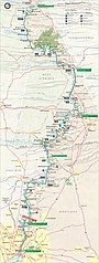
| Description | Map of the Chesapeake and Ohio Canal National Historical Park — along the former Chesapeake and Ohio Canal between Cumberland, Maryland, and Washington, D.C., USA. |
| Date | |
| Source | United States National Park Service, website for Chesapeake and Ohio Canal National Historical Park (http://www.nps.gov/choh/planyourvisit/parkmaps.htm). |
| Author | National Park Service, US Department of the Interior. |
| Permission (Reusing this file) |
Public domain - original work of the US Federal Government. |
Licensing
[edit].jpg&action=edit§ion=2)
| This image or media file contains material based on a work of a National Park Service employee, created as part of that person's official duties. As a work of the U.S. federal government, such work is in the public domain in the United States. See the NPS website and NPS copyright policy for more information. |
File history
Click on a date/time to view the file as it appeared at that time.
| Date/Time | Thumbnail | Dimensions | User | Comment | |
|---|---|---|---|---|---|
| current | 15:38, 6 February 2007 | 2,740 × 7,248 (6.8 MB) | Daderot (talk | contribs) | {{Information |Description=Map of the Chesapeake and Ohio Canal National Historical Park, along the former Chesapeake and Ohio Canal between Cumberland, Maryland, and Washington, D.C., USA. |Source=United States National Park Service, website for Chesapea |
You cannot overwrite this file.
File usage on Commons
There are no pages that use this file.
File usage on other wikis
The following other wikis use this file:
- Usage on da.wikipedia.org
- Usage on de.wikipedia.org
- Usage on en.wikipedia.org
- Usage on fr.wikipedia.org
- Usage on no.wikipedia.org
- Usage on pl.wikipedia.org
- Usage on zh.wikipedia.org
.jpg&oldid=855626009)