File:DaylightSaving-World-Subdivisions.png
Aller à la navigation
Aller à la recherche

Taille de cet aperçu : 800 × 355 pixels. Autres résolutions : 320 × 142 pixels | 640 × 284 pixels | 1 024 × 454 pixels | 1 280 × 568 pixels | 2 560 × 1 136 pixels | 4 952 × 2 197 pixels.
Fichier d’origine (4 952 × 2 197 pixels, taille du fichier : 463 kio, type MIME : image/png)
Légendes
Légendes
Ajoutez en une ligne la description de ce que représente ce fichier
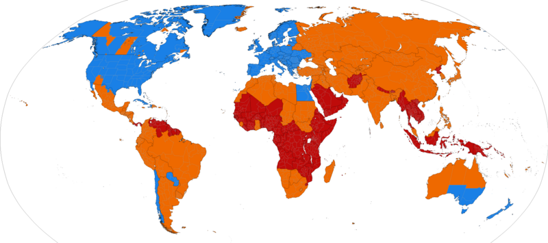
Daylight Saving World Subdivisions

|
Cette image (de type law-related map) devrait être recréée dans un format vectoriel, en tant que fichier SVG. Cela offrirait plusieurs avantages : voir Commons:Media for cleanup pour plus d'informations. Si une version SVG de cette image est déjà disponible, merci de bien vouloir l'envoyer. Après cela, remplacez ce modèle par {{vector version available|nouveau nom d'image.svg}}.
|
Description
| Description |
Bahasa Indonesia: Peta dunia yang menunjukkan wilayah yang masih menggunakan Waktu Musim Panas maupun yang (sudah) tidak menggunakannya.
Waktu Musim Panas masih digunakan.
Waktu Musim Panas sudah tidak digunakan.
Waktu Musim Panas tidak pernah digunakan. Català: Horari d'estiu.
S'utilitza el canvi d'hora.
Ja no s'utilitza el canvi d'hora.
Mai no s'ha utilitzat el canvi d'hora. Čeština: Aktuální a dřívější využívání letního času.
Využívá se letní čas.
Letní čas se už nevyužívá.
Letní čas se nikdy nevyužíval. Deutsch: Aktuelle und frühere Verwendung der Sommerzeit auf der Welt.
Sommerzeit benutzt.
Sommerzeit nicht mehr benutzt.
Sommerzeit nie benutzt. English: World map showing current and past daylight saving time usage. The Spring-forward/Fall-back adjustment is a common practice at high latitudes.
DST is used.
DST is no longer used.
DST has never been used. Español: Horario de verano en el mundo.
Se utiliza el cambio horario.
Ya no se utiliza el cambio horario.
Nunca se ha utilizado el cambio horario. Français : Carte du monde montrant l’utilisation actuelle et passée de l’heure d’été. Les changements aux règles de l’heure d’été ou les découvertes à propos des erreurs dans les données historiques peuvent nécessiter des modifications de l’image. Régions utilisant l’heure d’été.
Régions qui n’utilisent plus l’heure d’été.
Régions n’ayant jamais utilisé l’heure d’été. Italiano: Ora Legale.
Stati che adottano l’ora legale.
Stati che hanno utilizzato l'ora legale in passato.
Stati in cui non vi è mai stata l'ora legale. Nederlands: Zomertijd.
Gebieden die zomertijd gebruiken.
Gebieden die geen zomertijd meer gebruiken.
Gebieden die nooit zomertijd hebben gebruikt. Polski: Czas letni.
Obszary, które przyjęły czas letni.
Obszary, które kiedyś przyjęły czas letni, ale obecnie z niego nie korzystają.
Obszary, na których nigdy nie wprowadzono czasu letniego. Português do Brasil: Mapa mundial mostrando o atual e antigo uso do horário de verão. Alterações às regras do horário de verão, ou descobertas sobre erros nos dados históricos, devem requerir alterações à imagem. O horário de verão é usado.
O horário de verão não é mais usado.
O horário de verão nunca foi usado. Română: Harta lumii ilustrand statele care folosesc, au folosit, sau nu au folosit ora de vara. "Schimbarile regulilor legate de ora de vara sau descoperirile legate de erorile strecurate in datele istorice ar presupune modificari ale imaginii. Unde se foloseste ora de vara.
Unde nu se mai foloseste ora de vara in prezent.
Unde nu s-a folosit niciodata ora de vara. Scots: Warld cairt showin current an past daylicht savin time uisage. The Ware-forward/Hairst-back adjustment is a common practice at haich latitudes. Changes tae DST rules, or discoveries aboot errors in historical data, would require changes tae the image. DST is uised.
DST is no longer uised.
DST haes never been uised. Suomi: Kartta kesäajan käytöstä maailmanlaajuisesti. Kellojen siirto on yleisempää korkeammilla leveysasteilla.
Kesäaika on käytössä.
Kesäaika on joskus ollut käytössä.
Kesäaika ei ole koskaan ollut käytössä. Svenska: Karta som visar nutida respektive tidigare användande av sommartid, fördelat på stat.
Sommartid används.
Sommartid används ej längre.
Sommartid har aldrig använts. Русский: Карта мира, показывающая использование перехода на летнее время (DST) сейчас и в прошлом.
DST используется.
DST больше не используется.
DST никогда не использовалось. Українська: Карта світу, що демонструє використання "Літнього часу" зараз та в минулому.
Використовується літній час.
Припинилось використання літнього часу.
Літній час ніколи не використовувався. ქართული: მსოფლიოს რუქა, რომელიც აჩვენებს ზაფხულის დროის გამოყენებას. გაზაფხულის-წინ/შემოდგომის-უკან გადასვლა ჩვეულებრივი ამბავია მაღალ განედზე. ცვლილებები ზაფხულის დროის წესებში ან შეცდომების აღმოჩენა ისტორიულ მონაცემებში მოითხოვს ცვლილებას სურათში. ზაფხულის დრო გამოიყენება.
ზაფხულის დრო აღარ გამოიყენება.
ზაფხულის დრო არ გამოიყენებოდა არასდროს. עברית : מפה שמציגה את אימוץ שעון הקיץ במדינות שונות בעולם.
מדינות ואזורים המנהיגים שעון קיץ
מדינות ואזורים שהנהיגו בעבר שעון קיץ
מדינות ואזורים שלא הנהיגו שעון קיץ מעולם العربية :
تستعمل التوقيت الصيفي.
لم تعد تستعمل التوقيت الصيفي.
لم تستعمل التوقيت الصيفي مطلقاً. |
| Date | |
| Source | based on Image:BlankMap-World-Subdivisions.PNG, plus the data in the tz database, plus data in the maps on the INMS's Time Zones & Daylight Saving Time page. |
| Auteur | Paul Eggert |
| Autres versions |
Supplementary map: |

Conditions d’utilisation

|
Vous avez la permission de copier, distribuer et modifier ce document selon les termes de la GNU Free Documentation License version 1.2 ou toute version ultérieure publiée par la Free Software Foundation, sans sections inaltérables, sans texte de première page de couverture et sans texte de dernière page de couverture. Un exemplaire de la licence est inclus dans la section intitulée GNU Free Documentation License. |
| Ce fichier est disponible selon les termes de la licence Creative Commons Attribution – Partage dans les Mêmes Conditions 3.0 (non transposée). | ||
| ||
| Ce bandeau de licence a été ajouté à ce fichier dans le cadre de la procédure de mise à jour des licences des images sous GFDL. |
Historique du fichier
Cliquer sur une date et heure pour voir le fichier tel qu'il était à ce moment-là.
| Date et heure | Vignette | Dimensions | Utilisateur | Commentaire | |
|---|---|---|---|---|---|
| actuel | 31 mars 2024 à 06:06 | | 4 952 × 2 197 (463 kio) | Heitordp (d | contributions) | Adjusted Greenland |
| 31 décembre 2023 à 11:25 |  | 4 952 × 2 197 (463 kio) | Heitordp (d | contributions) | Updated Greenland, disputed borders, subdivisions of France, Morocco, DR Congo, South Sudan, Ethiopia, Somalia, India | |
| 23 avril 2023 à 09:44 |  | 4 952 × 2 197 (463 kio) | Heitordp (d | contributions) | Updated Ukraine | |
| 5 avril 2023 à 21:52 |  | 4 952 × 2 197 (463 kio) | Heitordp (d | contributions) | Updated most of Greenland, law specifies UTC–2 with no DST in 2023 | |
| 27 mars 2023 à 13:31 |  | 4 952 × 2 197 (463 kio) | Heitordp (d | contributions) | Corrected northeast Greenland and Qikiqtaaluk island | |
| 1 mars 2023 à 20:57 |  | 4 952 × 2 197 (463 kio) | Heitordp (d | contributions) | Updated Egypt, adjusted Kazakhstan | |
| 30 novembre 2022 à 06:50 |  | 4 952 × 2 197 (463 kio) | Heitordp (d | contributions) | Updated Mexico | |
| 20 novembre 2022 à 08:01 |  | 4 952 × 2 197 (463 kio) | Heitordp (d | contributions) | Removed Antarctica, added globe outline | |
| 30 octobre 2022 à 09:31 |  | 4 972 × 2 492 (467 kio) | Heitordp (d | contributions) | Updated Mexico; adjusted US, Canada, Greenland | |
| 6 octobre 2022 à 02:02 |  | 4 972 × 2 492 (467 kio) | Heitordp (d | contributions) | Updated Jordan and Syria |
Vous ne pouvez pas remplacer ce fichier.
Utilisations locales du fichier
Les 48 pages suivantes utilisent ce fichier :
- User:Chumwa/OgreBot/Potential transport maps/2016 August 11-20
- User:Chumwa/OgreBot/Potential transport maps/2016 December 1-10
- User:Chumwa/OgreBot/Potential transport maps/2016 December 21-31
- User:Chumwa/OgreBot/Potential transport maps/2016 July 1-10
- User:Chumwa/OgreBot/Potential transport maps/2016 June 11-20
- User:Chumwa/OgreBot/Potential transport maps/2016 March 11-20
- User:Chumwa/OgreBot/Potential transport maps/2016 November 1-10
- User:Chumwa/OgreBot/Potential transport maps/2016 October 11-20
- User:Chumwa/OgreBot/Potential transport maps/2016 September 1-10
- User:Chumwa/OgreBot/Potential transport maps/2016 September 11-20
- User:Chumwa/OgreBot/Potential transport maps/2017 February 10-18
- User:Chumwa/OgreBot/Potential transport maps/2017 January 1-10
- User:Chumwa/OgreBot/Transport Maps/2015 April 1-10
- User:Chumwa/OgreBot/Transport Maps/2015 July 1-10
- User:Chumwa/OgreBot/Transport Maps/2015 June 21-30
- User:Chumwa/OgreBot/Transport Maps/2015 March 11-20
- User:Chumwa/OgreBot/Transport Maps/2015 March 21-31
- User:Chumwa/OgreBot/Transport Maps/2016 August 11-20
- User:Chumwa/OgreBot/Transport Maps/2016 December 1-10
- User:Chumwa/OgreBot/Transport Maps/2016 December 21-31
- User:Chumwa/OgreBot/Transport Maps/2016 July 1-10
- User:Chumwa/OgreBot/Transport Maps/2016 June 11-20
- User:Chumwa/OgreBot/Transport Maps/2016 March 1-10
- User:Chumwa/OgreBot/Transport Maps/2016 March 11-20
- User:Chumwa/OgreBot/Transport Maps/2016 November 1-10
- User:Chumwa/OgreBot/Transport Maps/2016 October 11-20
- User:Chumwa/OgreBot/Transport Maps/2016 September 1-10
- User:Chumwa/OgreBot/Transport Maps/2016 September 11-20
- User:Chumwa/OgreBot/Transport Maps/2017 February 10-18
- User:Chumwa/OgreBot/Transport Maps/2017 January 1-10
- User:Chumwa/OgreBot/Travel and communication maps/2016 August 11-20
- User:Chumwa/OgreBot/Travel and communication maps/2016 December 1-10
- User:Chumwa/OgreBot/Travel and communication maps/2016 December 21-31
- User:Chumwa/OgreBot/Travel and communication maps/2016 July 1-10
- User:Chumwa/OgreBot/Travel and communication maps/2016 June 11-20
- User:Chumwa/OgreBot/Travel and communication maps/2016 March 1-10
- User:Chumwa/OgreBot/Travel and communication maps/2016 March 11-20
- User:Chumwa/OgreBot/Travel and communication maps/2016 November 1-10
- User:Chumwa/OgreBot/Travel and communication maps/2016 October 11-20
- User:Chumwa/OgreBot/Travel and communication maps/2016 September 1-10
- User:Chumwa/OgreBot/Travel and communication maps/2016 September 11-20
- User:Chumwa/OgreBot/Travel and communication maps/2017 February 10-18
- User:Chumwa/OgreBot/Travel and communication maps/2017 January 1-10
- User talk:Phoenix B 1of3
- File:DST Countries (September 2011).png
- File:DST Countries Map.png
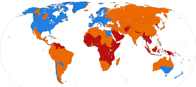
- File:DaylightSaving-World-Subdivisions-new version 2015.png
- Category:Daylight saving time
.png)
Utilisations du fichier sur d’autres wikis
Les autres wikis suivants utilisent ce fichier :
- Utilisation sur af.wikipedia.org
- Utilisation sur an.wikipedia.org
- Utilisation sur ar.wikipedia.org
- Utilisation sur arz.wikipedia.org
- Utilisation sur ast.wikipedia.org
- Utilisation sur as.wikipedia.org
- Utilisation sur azb.wikipedia.org
- Utilisation sur az.wikipedia.org
- Utilisation sur bat-smg.wikipedia.org
- Utilisation sur ba.wikipedia.org
- Utilisation sur be-tarask.wikipedia.org
- Utilisation sur be.wikipedia.org
- Utilisation sur bg.wikipedia.org
- Utilisation sur bn.wikipedia.org
- Utilisation sur br.wikipedia.org
- Utilisation sur bs.wikipedia.org
- Utilisation sur ca.wikipedia.org
- Utilisation sur ce.wikipedia.org
- Utilisation sur cs.wikipedia.org
- Utilisation sur cv.wikipedia.org
- Utilisation sur da.wikipedia.org
- Utilisation sur de.wikipedia.org
- Zeitzone
- Sommerzeit
- Vorlage Diskussion:Farblegende
- Liste der Sommerzeiten
- Diskussion:Atlantische Hurrikansaison 2011
- Wikipedia:Kartenwerkstatt/Archiv/Zurückgewiesene und zurückgestellte Aufträge 2012
- Wikipedia:Vandalismusmeldung/Archiv/2014/10/08
- Wikipedia:Auskunft/Archiv/2017/Woche 43
- Wikipedia:Café/Archiv 2020 Q4
- Utilisation sur de.wikinews.org
- Utilisation sur diq.wikipedia.org
- Utilisation sur el.wikipedia.org
- Utilisation sur en.wikipedia.org
- Time zone
- User:Hazelorb/Time zone
- User talk:Phoenix B 1of3/Archive 4
- Wikipedia:Top 25 Report/November 2 to 8, 2014
- Wikipedia:Wikipedia Signpost/2015-03-18/Traffic report
- Wikipedia:Wikipedia Signpost/Single/2015-03-18
- Wikipedia:Top 25 Report/March 8 to 14, 2015
- Wikipedia:Graphics Lab/Map workshop/Archive/2016
- Utilisation sur eo.wikipedia.org
Voir davantage sur l’utilisation globale de ce fichier.