File:Death Valley NP master map.png
Jump to navigation
Jump to search
Size of this preview: 546 × 599 pixels. Other resolutions: 219 × 240 pixels | 437 × 480 pixels | 853 × 936 pixels.
Original file (853 × 936 pixels, file size: 951 KB, MIME type: image/png)
Captions
Captions
Add a one-line explanation of what this file represents
Summary[edit]
| Description |
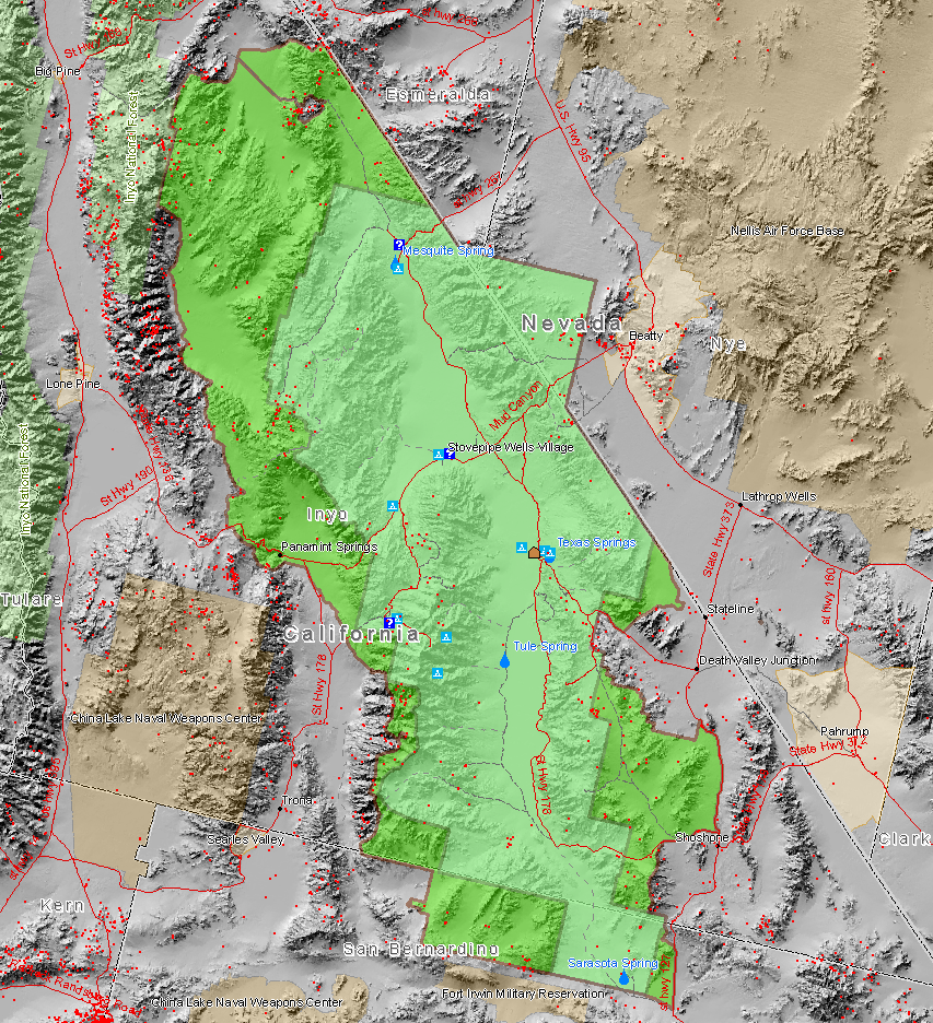
English: Map of the Death Valley National Park showing surrounding area and the previous smaller extent of the Park. Red dots are mine sites, blue triangles are camp sites, and blue question marks are tourist information facilities. This map also shows the old borders of Death Valley National Monument and the new borders of the expanded national park.
Français : Carte du parc et de ses environs.
Magyar: A nemzeti park térképe.
עברית: מפת הפארק הלאומי עמק המוות.
Български: В зелено са отбелязани границите на днешната Долина на смъртта. |
| Source | Map created by Daniel Mayer using data from the National Park Service metadata |
| Author | user:maveric149 (Daniel Mayer) |
| Permission (Reusing this file) |
I, the copyright holder of this work, hereby publish it under the following license: This file is licensed under the Creative Commons Attribution-Share Alike 2.5 Generic license.
|
File history
Click on a date/time to view the file as it appeared at that time.
| Date/Time | Thumbnail | Dimensions | User | Comment | |
|---|---|---|---|---|---|
| current | 21:59, 1 January 2009 | | 853 × 936 (951 KB) | Mahahahaneapneap (talk | contribs) | Compressed |
| 01:30, 9 March 2006 |  | 853 × 936 (1.22 MB) | Mav (talk | contribs) | Map created by Daniel Mayer using data from the National Park Service [http://science.nature.nps.gov/nrdata/metadata.cfm?ID=16872 metadata] |
You cannot overwrite this file.
File usage on Commons
The following 2 pages use this file:
File usage on other wikis
The following other wikis use this file:
- Usage on bg.wikipedia.org
- Usage on de.wikipedia.org
- Usage on en.wikipedia.org
- Usage on eu.wikipedia.org
- Usage on fa.wikipedia.org
- Usage on fr.wikipedia.org
- Parc national de la vallée de la Mort
- Wikipédia:Lumière sur/Mars 2005
- Wikipédia:Lumière sur/Février 2007
- Wikipédia:Lumière sur/Août 2007
- Wikipédia:Lumière sur/Parc national de la vallée de la Mort
- Wikipédia:Sélection/Géographie
- Wikipédia:Sélection/Amérique
- Portail:Information géographique/Sélection
- Wikipédia:Sélection/Désert
- Usage on he.wikipedia.org
- Usage on hu.wikipedia.org
- Usage on is.wikipedia.org
- Usage on pl.wikipedia.org
- Usage on zh.wikipedia.org