File:Dust storm over Libya.jpg

Fichier d’origine (2 000 × 1 556 pixels, taille du fichier : 839 kio, type MIME : image/jpeg)
Légendes
Légendes
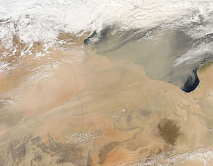
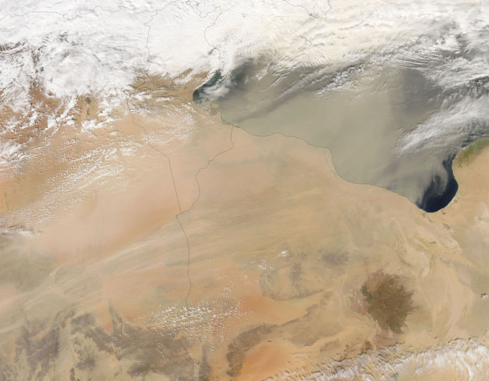
Dust Storm over Libya and Egypt A thin sheet of dust blew northeastward from deserts in northern Africa and out across the Mediterranean Sea (upper right) on March 1, 2005. The orange-colored sands of eastern Algeria are thickly veiled with light-colored dust, which thins as it spreads more widely over Tunisia and Libya. The dust weaves both under and over clouds in different places over the Mediterranean. At the far right edge, the clouds appear bright white, and appear to be casting a shadow on the dust plume below them. At top center, dust appears to be above the clouds, giving them a dirty appearance. This image was made from data collected by the Moderate Resolution Imaging Spectroradiometer (MODIS) on NASA’s Aqua satellite.
NASA image courtesy Jeff Schmaltz, MODIS Rapid Response Team, NASA-GSFC
http://earthobservatory.nasa.gov/NaturalHazards/natural_hazards_v2.php3?img_id=12746 copie d'archive sur Wayback Machine
| Ce fichier provient de la NASA. Sauf exception, les documents créés par la NASA ne sont pas soumis à copyright. Pour plus d'informations, voir la politique de copyright de la NASA. | ||
 |
Attention :
|
Historique du fichier
Cliquer sur une date et heure pour voir le fichier tel qu'il était à ce moment-là.
| Date et heure | Vignette | Dimensions | Utilisateur | Commentaire | |
|---|---|---|---|---|---|
| actuel | 25 octobre 2005 à 12:56 | | 2 000 × 1 556 (839 kio) | Brian0918 (d | contributions) | Dust Storm over Libya and Egypt A thin sheet of dust blew northeastward from deserts in northern Africa and out across the Mediterranean Sea (upper right) on March 1, 2005. The orange-colored sands of eastern Algeria are thickly veiled with light-colored |
Vous ne pouvez pas remplacer ce fichier.
Utilisations locales du fichier
La page suivante utilise ce fichier :
Utilisations du fichier sur d’autres wikis
Les autres wikis suivants utilisent ce fichier :
- Utilisation sur ar.wikipedia.org
- Utilisation sur bg.wikipedia.org
- Utilisation sur bh.wikipedia.org
- Utilisation sur bn.wikipedia.org
- Utilisation sur da.wikipedia.org
- Utilisation sur de.wikipedia.org
- Utilisation sur el.wikipedia.org
- Utilisation sur en.wikipedia.org
- Utilisation sur eo.wikipedia.org
- Utilisation sur eu.wikipedia.org
- Utilisation sur fa.wikipedia.org
- Utilisation sur fr.wikipedia.org
- Utilisation sur gd.wikipedia.org
- Utilisation sur ig.wikipedia.org
- Utilisation sur ja.wikipedia.org
- Utilisation sur ka.wikipedia.org
- Utilisation sur kk.wikipedia.org
- Utilisation sur ko.wikipedia.org
- Utilisation sur lt.wikipedia.org
- Utilisation sur mk.wikipedia.org
- Utilisation sur ml.wikipedia.org
- Utilisation sur nn.wikipedia.org
- Utilisation sur no.wikipedia.org
- Utilisation sur pt.wikipedia.org
- Utilisation sur ru.wikipedia.org
- Utilisation sur sv.wikipedia.org
- Utilisation sur uk.wikipedia.org
Métadonnées
- Photos of dust storms by the Aqua (satellite) MODIS
- NASA MODIS images of Africa
- Satellite pictures of Libya
- Satellite pictures of Tunisia
- Causes of erosion
- Khamsin
- Dust storms in Egypt
- Dust storms in Libya
- Aeolian sediment transport in Africa
- Aeolian sediment transport in Libya
- Dust storms in Tunisia
- Gulf of Sirte