File:Estergebirge beschriftet.jpg
Jump to navigation
Jump to search

Size of this preview: 800 × 237 pixels. Other resolutions: 320 × 95 pixels | 640 × 189 pixels | 1,024 × 303 pixels | 2,702 × 800 pixels.
Original file (2,702 × 800 pixels, file size: 413 KB, MIME type: image/jpeg)
Captions
Captions
Add a one-line explanation of what this file represents
Summary[edit]
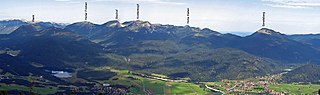
| Description | southeast view of Estergebirge. Wank, Hoher Fricken, Krottenkopf, ... Krün und Wallgau. |
| Date | |
| Source | photo taken by Kogo |
| Author | Kogo |
| Permission (Reusing this file) |
GFDL |
| Camera location | | View this and other nearby images on: OpenStreetMap |
|---|
Licensing[edit]
I, the copyright holder of this work, hereby publish it under the following license:

|
Permission is granted to copy, distribute and/or modify this document under the terms of the GNU Free Documentation License, Version 1.2 or any later version published by the Free Software Foundation; with no Invariant Sections, no Front-Cover Texts, and no Back-Cover Texts. A copy of the license is included in the section entitled GNU Free Documentation License. |
File history
Click on a date/time to view the file as it appeared at that time.
| Date/Time | Thumbnail | Dimensions | User | Comment | |
|---|---|---|---|---|---|
| current | 20:38, 15 September 2006 | 2,702 × 800 (413 KB) | Kogo (talk | contribs) | {{Information |Description= northeast view of Estergebirge |Source=photo taken by Kogo |Date=20. August 2006 |Author=Kogo |Permission=GFDL |other_versions= }} |
You cannot overwrite this file.
File usage on Commons
The following page uses this file:
File usage on other wikis
The following other wikis use this file:
- Usage on de.wikipedia.org
- Usage on en.wikipedia.org
- Usage on fr.wikipedia.org
- Usage on hi.wikipedia.org
- Usage on nn.wikipedia.org
- Usage on uk.wikipedia.org