File:Gonu 04 jun 2007 0900Z.jpg

Original file (5,400 × 5,400 pixels, file size: 3.66 MB, MIME type: image/jpeg)
Captions
Captions
Summary[edit]
| Description |
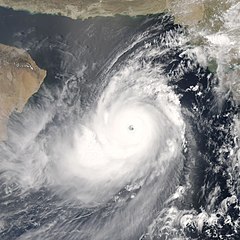
You might expect to see a storm with near-perfect symmetry and a well-defined eye hoovering over the warm waters of the Caribbean or in the South Pacific, but Tropical Cyclone Gonu showed up in an unusual place. On June 4, 2007, when the Moderate Resolution Imaging Spectroradiometer (MODIS) on NASA’s Aqua satellite captured this image, Tropical Cyclone Gonu was approaching the northeastern shore of Oman, a region better known for hot desert conditions. Though rare, cyclones like Gonu are not unheard of in the northern Indian Ocean basin. Most cyclones that form in the region form over the Bay of Bengal, east of India. Those that take shape over the Arabian Sea, west of the Indian peninsula, tend to be small and fizzle out before coming ashore. Cyclone Gonu is a rare exception. As of June 4, 2007, the powerful storm had reached a dangerous Category Four status, and it was forecast to graze Oman’s north-eastern shore, following the Gulf of Oman. According to storm statistics maintained on Unisys Weather, the last storm of this size to form over the Arabian Sea was Cyclone 01A, which tracked northwest along the coast of India between May 21 and May 28, 2001. Unlike Gonu’s forecasted track, Cyclone 01A never came ashore. MODIS acquired this photo-like image at 12:00 p.m. local time (9:00 UTC), a few hours after the Joint Typhoon Warning Center estimated Gonu’s sustained winds to be over 240 kilometers per hour (145 miles per hour). The satellite image confirms that Gonu was a super-powerful cyclone. The storm has the hallmark tightly wound arms that spiral around a well-defined, circular eye. The eye is surrounded by a clear wall of towering clouds that cast shadows on the surrounding clouds. Called hot towers, these clouds are a sign of the powerful uplift that feeds the storm. The symmetrical spirals, clear eye, and towering clouds are all features regularly seen in satellite images of other particularly powerful cyclones, which are also known as typhoons or hurricanes when they form in other parts of the world. The high-resolution image provided above is at MODIS’ full spatial resolution (level of detail) of 250 meters per pixel. The MODIS Rapid Response System provides this image at additional resolutions. |
|||||
| Date | ||||||
| Source | http://earthobservatory.nasa.gov/NaturalHazards/natural_hazards_v2.php3?img_id=14287 | |||||
| Author | NASA image by Jeff Schmaltz, MODIS Rapid Response Team, Goddard Space Flight Center. | |||||
| Permission (Reusing this file) |
|
|||||
| Other versions | Full version: Image:Gonu 04 jun 2007 0900Z lg.jpg |

File history
Click on a date/time to view the file as it appeared at that time.
| Date/Time | Thumbnail | Dimensions | User | Comment | |
|---|---|---|---|---|---|
| current | 20:49, 4 June 2007 | | 5,400 × 5,400 (3.66 MB) | Good kitty (talk | contribs) | == Summary == {{Information |Description=You might expect to see a storm with near-perfect symmetry and a well-defined eye hoovering over the warm waters of the Caribbean or in the South Pacific, but Tropical Cyclone Gonu showed up in an unusual place. On |
You cannot overwrite this file.
File usage on Commons
There are no pages that use this file.
File usage on other wikis
The following other wikis use this file:
- Usage on ar.wikipedia.org
- Usage on de.wikipedia.org
- Usage on en.wikipedia.org
- Usage on en.wikinews.org
- Usage on pl.wikinews.org
- Usage on te.wikipedia.org
- Usage on ur.wikipedia.org