File:Gv-map.gif
Jump to navigation
Jump to search
No higher resolution available.
Gv-map.gif (330 × 355 pixels, file size: 12 KB, MIME type: image/gif)
Captions
Captions
Add a one-line explanation of what this file represents
Summary[edit]
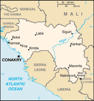
| Description | English map of Guinea |
| Date | |
| Source | CIA World Factbook |
| Author | United States Central Intelligence Agency |
| Permission (Reusing this file) |
PD |
| Other versions | French version : Image:Guinee_carte.png |
Français : * Sujet : Carte en anglais de la Guinéee ;
- Source : CIA World Factbook ;
- Autre version disponible : francophone : Image:Guinee_carte.png
- Date : Juin 2006.
Licensing[edit]
This image is in the public domain because it contains materials that originally came from the United States Central Intelligence Agency's World Factbook.
|
 |
File history
Click on a date/time to view the file as it appeared at that time.
| Date/Time | Thumbnail | Dimensions | User | Comment | |
|---|---|---|---|---|---|
| current | 22:15, 16 June 2006 | | 330 × 355 (12 KB) | Sting (talk | contribs) | {{Information |Description=English map of Guinea |Source=[http://www.cia.gov/cia/publications/factbook/ CIA World Factbook] |Date=June 2006 |Author=United States Central Intelligence Agency |Permission=PD |other_versions=French version : [[:Image:Guinee_c |
You cannot overwrite this file.
File usage on Commons
The following page uses this file:
File usage on other wikis
The following other wikis use this file:
- Usage on ca.wikipedia.org
- Usage on es.wikipedia.org
- Usage on gl.wikipedia.org
- Usage on hu.wikipedia.org
- Usage on hu.wiktionary.org
- Usage on lfn.wikipedia.org
- Usage on mr.wikipedia.org
- Usage on pt.wikipedia.org
- Usage on sq.wikipedia.org
- Usage on uk.wikipedia.org