File:Hacha grande from papagayo pano.jpg
Przejdź do nawigacji
Przejdź do wyszukiwania
Rozmiar podglądu – 800 × 181 pikseli. Inne rozdzielczości: 320 × 72 pikseli | 640 × 145 pikseli | 1024 × 231 pikseli | 4000 × 904 pikseli.
Rozmiar pierwotny (4000 × 904 pikseli, rozmiar pliku: 1,79 MB, typ MIME: image/jpeg)
Podpisy
Podpisy
Dodaj jednolinijkowe objaśnienie tego, co ten plik pokazuje
Hacha Grande detta anche Cima Segantini
|

Opis[edytuj]
| Pozycja fotografa | | To i inne zdjęcia na: OpenStreetMap |
|---|
| Opis |
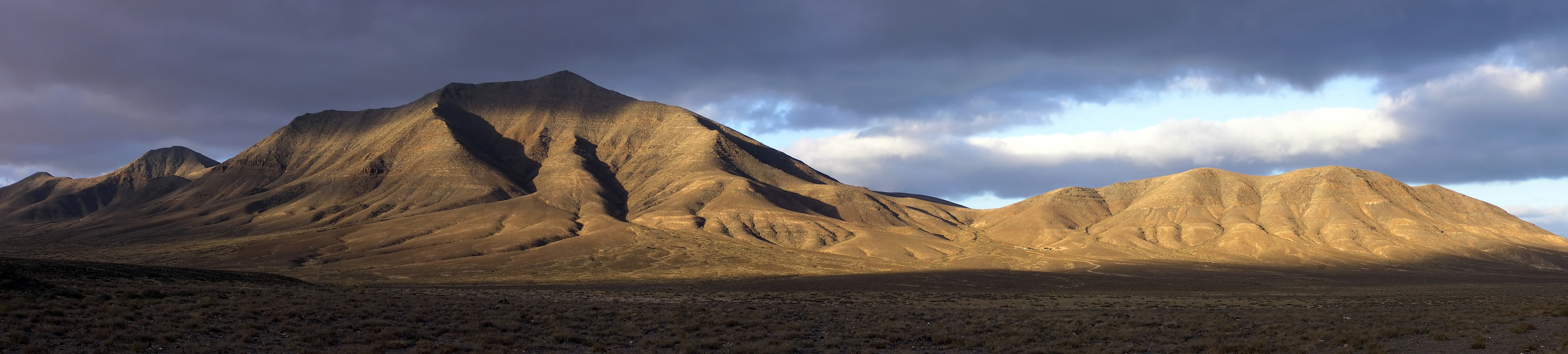
English: Hacha Grande (562m), the Degollada Valle Perdomo, Montaña Breña Estesa and the Morros de Hacha Chica (left to right) viewed across the arid plain of El Rubicón from the road to the Monumento Natural de los Ajaches (Punta de Papagayo), on the Canary Island of Lanzarote. Pico Redondo (562m) is visible on the far left. Lanzarote is a volcanic island with very low rainfall; much of the south of the island is desert and a barren expanse of lava flows. Lanzarote (Canary Islands, Spain).
Français : De gauche à droite : Pico Redondo (loin à gauche, 562m), Hacha Grande (562m), la Degollada Valle Perdomo, la Montaña Breña Estesa et les Morros de Hacha Chica, vus derrière les plaines arides d'El Rubicón depuis la route menant au Monumento Natural de los Ajaches (Punta de Papagayo), sur l'île de Lanzarote, dans les Canaries (Espagne). Lanzarote est une île volcanique et aride, le sud de l'île est un désert de laves. |
| Data | |
| Źródło | Praca własna |
| Autor | Yummifruitbat |
| Licencja (Ponowne użycie tego pliku) |
See license details |
Location from Wikipedia en:Hacha_Grande.
Licencja[edytuj]
Ja, właściciel praw autorskich do tego dzieła, udostępniam je na poniższej licencji
Ten plik udostępniony jest na licencji Creative Commons Uznanie autorstwa – Na tych samych warunkach 2.5.
- Wolno:
- dzielić się – kopiować, rozpowszechniać, odtwarzać i wykonywać utwór
- modyfikować – tworzyć utwory zależne
- Na następujących warunkach:
- uznanie autorstwa – musisz określić autorstwo utworu, podać link do licencji, a także wskazać czy utwór został zmieniony. Możesz to zrobić w każdy rozsądny sposób, o ile nie będzie to sugerować, że licencjodawca popiera Ciebie lub Twoje użycie utworu.
- na tych samych warunkach – Jeśli zmienia się lub przekształca niniejszy utwór, lub tworzy inny na jego podstawie, można rozpowszechniać powstały w ten sposób nowy utwór tylko na podstawie tej samej lub podobnej licencji.
| Adnotacje | To zdjęcie jest opatrzone adnotacją: Zobacz adnotacje w Commons |
Historia pliku
Kliknij na odpowiedniej dacie/czasie, aby zobaczyć wersję pliku z tamtego okresu.
| Data/czas | Miniatura | Wymiary | Użytkownik | Opis | |
|---|---|---|---|---|---|
| aktualny | 19:21, 31 lip 2006 | 4000 × 904 (1,79 MB) | Yummifruitbat (dyskusja | edycje) | {{Information |Description=Hacha Grande (562m), the Degollada Valle Perdomo, Montaña Breña Estesa and the Morros de Hacha Chica (left to right) viewed across the arid plain of El Rubicón from the road to the Monumento Natural de los Ajaches (Punta de |
Nie możesz nadpisać tego pliku.
Lokalne wykorzystanie pliku
Następujące strony korzystają z tego pliku:
- Islas Canarias
- User:Yummifruitbat
- User:Ö/Best/2010
- User talk:Ggia
- Commons:Featured picture candidates/File:Hacha grande from papagayo pano.jpg
- Commons:Featured picture candidates/Log/December 2010
- Commons:Featured pictures/Places/Natural/Spain
- Commons:Featured pictures/Places/Panoramas
- Commons:Featured pictures/chronological/2010-B
- Commons:Picture of the Year/2010/Galleries/Index/16
- Commons:Picture of the Year/2010/Galleries/Index/Panoramas
- Commons:Picture of the Year/2010/Galleries/Panoramas
- Commons:Picture of the Year/2010/Galleries/Panoramas/Large
- Commons:Picture of the Year/2010/Galleries/Panoramas/Small
- Commons:Picture of the Year/2010/Galleries/Table
- Commons:Picture of the Year/2010/Galleries/Table/12
- Commons:Picture of the Year/2010/R1/File:Hacha grande from papagayo pano.jpg
- Commons:Picture of the Year/2010/Results/R1/ALL/Table
- Commons:Picture of the Year/2010/Results/R1/Panoramas
- Commons:Picture of the Year/2010/Results/R1/Panoramas/Table
- Commons talk:Picture of the Year/2010/Galleries/Table
- Commons talk:Picture of the Year/2010/Results/R1/ALL/Table
- Category:Hacha Grande
Globalne wykorzystanie pliku
Ten plik jest wykorzystywany także w innych projektach wiki:
- Wykorzystanie na bn.wikipedia.org
- Wykorzystanie na ceb.wikipedia.org
- Wykorzystanie na de.wikipedia.org
- Wykorzystanie na el.wikipedia.org
- Wykorzystanie na en.wikipedia.org
- Canary Islands
- Lanzarote
- Yaiza (municipality)
- Wikipedia:Featured pictures thumbs/04
- Wikipedia:Picture of the day/October 2006
- Wikipedia:Featured picture candidates/Hacha grande from papagayo pano.jpg
- Wikipedia:Featured picture candidates/August-2006
- Hacha Grande
- Wikipedia:Wikipedia Signpost/2006-08-14/Features and admins
- Wikipedia:Picture of the day/October 4, 2006
- Wikipedia:POTD/October 4, 2006
- Wikipedia:POTD column/October 4, 2006
- Wikipedia:POTD row/October 4, 2006
- Wikipedia:Featured pictures/Places/Panorama
- User talk:Yummifruitbat/Archive 1
- Portal:Spain/Exemplary content
- Portal:Europe/Selected panorama
- Portal:Europe/Selected panorama/6
- Wikipedia:WikiProject Volcanoes/Content
- Wikipedia:WikiProject Spain/Recognized content
- User:Godspeed1715/sandbox
- Wikipedia:Wikipedia Signpost/Single/2006-08-14
- Wykorzystanie na en.wikivoyage.org
- Wykorzystanie na eu.wikipedia.org
- Wykorzystanie na fa.wikipedia.org
- Wykorzystanie na fi.wikipedia.org
- Wykorzystanie na fy.wikipedia.org
- Wykorzystanie na id.wikipedia.org
- Wykorzystanie na it.wikipedia.org
- Wykorzystanie na lb.wikipedia.org
- Wykorzystanie na lld.wikipedia.org
- Wykorzystanie na lt.wikipedia.org
- Wykorzystanie na mk.wikipedia.org
- Wykorzystanie na nn.wikipedia.org
- Wykorzystanie na pl.wikipedia.org
Pokaż listę globalnego wykorzystania tego pliku.