File:Helios Airways Flight 522 remi.png
Original file (1,440 × 900 pixels, file size: 407 KB, MIME type: image/png)
Captions
Captions

|
This incident map image could be re-created using vector graphics as an SVG file. This has several advantages; see Commons:Media for cleanup for more information. If an SVG form of this image is available, please upload it and afterwards replace this template with
{{vector version available|new image name}}.
It is recommended to name the SVG file “Helios Airways Flight 522 remi.svg”—then the template Vector version available (or Vva) does not need the new image name parameter. |
Summary
[edit]
| Description |
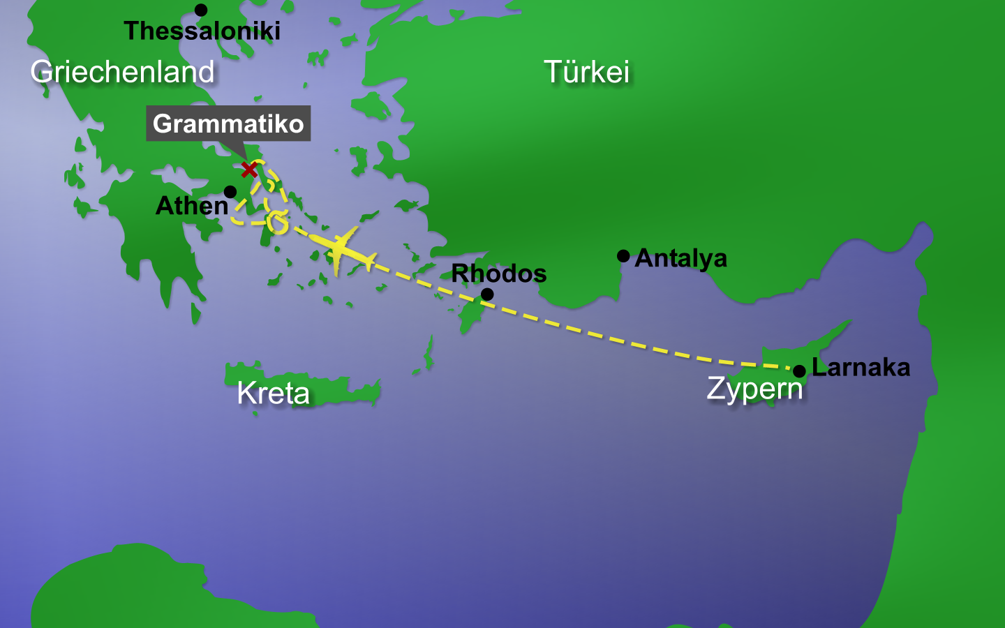
Deutsch: Karte des Helios Airways Fluges 522.
Helios Airways Flug 522 stürzte nahe der Stadt Grammtiko in Griechenland, etwa 10 km entfernt vom Athener Flughafen mit 121 Passagieren an Bord ab. Die Karte zeigt den original Flugverlauf am Zielgebiet. Der Autopilot steuerte das Flugzeug zunächst in Richtung Flughafen Athen, flog dann Richtung Süden und zog längere Zeit Schleifen über der Ägais. Danach flog das Flugzeug wieder Richtung Flughafen Athen, bis es nahe Grammatiko abstürzte. Als Quelle hierzu dienten die Radarplots [1] zum Flug. Im Startgebiet kann die Zeichnung jedoch ungenau sein, da hierzu (bisher) noch kein Radarplot verfügbar ist. |
| Date | |
| Source | graphic created by Remi |
| Author | Remi |
| Permission (Reusing this file) |
Remi released it under GFDL |
| Other versions |
This graphic is available in different languages.
|
Bildverweise
[edit]
- de:Helios Airways Flug 522
- please edit and complete this list
Übersetzungen
[edit]
If you need the map in another language, please look at Image_talk:Helios_airways_flight_522_en_remi.png.
Licensing
[edit]

|
Permission is granted to copy, distribute and/or modify this document under the terms of the GNU Free Documentation License, Version 1.2 or any later version published by the Free Software Foundation; with no Invariant Sections, no Front-Cover Texts, and no Back-Cover Texts. A copy of the license is included in the section entitled GNU Free Documentation License. |
| This file is licensed under the Creative Commons Attribution-Share Alike 3.0 Unported license. | ||
| ||
| This licensing tag was added to this file as part of the GFDL licensing update. |
File history
Click on a date/time to view the file as it appeared at that time.
| Date/Time | Thumbnail | Dimensions | User | Comment | |
|---|---|---|---|---|---|
| current | 10:41, 20 August 2005 | | 1,440 × 900 (407 KB) | Remi~commonswiki (talk | contribs) | |
| 01:39, 20 August 2005 |  | 1,440 × 900 (400 KB) | Remi~commonswiki (talk | contribs) | akkuratere Version | |
| 13:27, 19 August 2005 |  | 1,440 × 900 (416 KB) | Remi~commonswiki (talk | contribs) | Karte vom Absturzgebiet des Helios Airways Fluges 522 nahe der Stadt Grammtiko in Griechenland, etwa 10 km entfernt vom Athener Flughafen. Source: User:Remi - selbst gezeichnet {{GFDL}} [[Cat |
You cannot overwrite this file.
File usage on Commons
The following page uses this file:
File usage on other wikis
The following other wikis use this file:
- Usage on de.wikipedia.org