File:Lorraine geologic map andra.svg
Jump to navigation
Jump to search

Size of this PNG preview of this SVG file: 600 × 600 pixels. Other resolutions: 240 × 240 pixels | 480 × 480 pixels | 768 × 768 pixels | 1,024 × 1,024 pixels | 2,048 × 2,048 pixels | 1,300 × 1,300 pixels.
Original file (SVG file, nominally 1,300 × 1,300 pixels, file size: 338 KB)
Captions
Captions
Add a one-line explanation of what this file represents
Summary[edit]
| Description | |
| Date | |
| Source | Based upon the map from the university of Nancy-Metz |
| Author | Eric Gaba (Sting) modified by Emmanuel Boutet in march 2007 |
| Permission (Reusing this file) |
CC-BY-SA-2.5 |
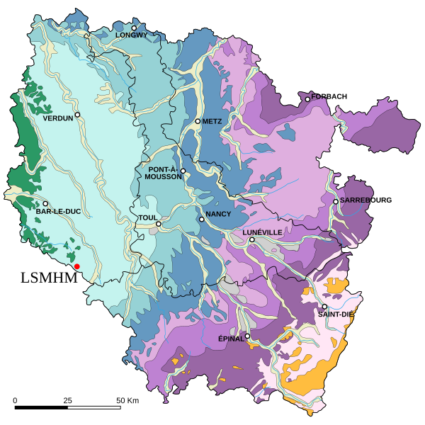
Key :
Recent alluvium
Ancient alluvium
Cretaceous
Upper Jurassic
Middle Jurassic
Lower Jurassic
Upper Triassic
Middle Triassic
Lower Triassic
Hercynian granites
Paleozoic and earlier
Français : Carte géologique de la Lorraine (France), avec l'indication de l'ANDRA, Laboratoire de recherche souterrain de Meuse/Haute-Marne, Route Départementale 960 - BP 9, 55290 BURE, Tél : 03 29 75 90 00, [1]
Légende :
Alluvions récentes
Alluvions anciennes
Crétacé
Jurassique supérieur
Jurassique moyen
Jurassique inférieur
Trias supérieur
Trias moyen
Trias inférieur
Granites hercyniens
Paléozoïque et antérieur
Licensing[edit]
I, the copyright holder of this work, hereby publish it under the following license:
This file is licensed under the Creative Commons Attribution-Share Alike 2.5 Generic license.
- You are free:
- to share – to copy, distribute and transmit the work
- to remix – to adapt the work
- Under the following conditions:
- attribution – You must give appropriate credit, provide a link to the license, and indicate if changes were made. You may do so in any reasonable manner, but not in any way that suggests the licensor endorses you or your use.
- share alike – If you remix, transform, or build upon the material, you must distribute your contributions under the same or compatible license as the original.
File history
Click on a date/time to view the file as it appeared at that time.
| Date/Time | Thumbnail | Dimensions | User | Comment | |
|---|---|---|---|---|---|
| current | 11:21, 19 March 2007 | | 1,300 × 1,300 (338 KB) | Emmanuel.boutet (talk | contribs) | |
| 19:08, 16 March 2007 |  | 1,300 × 1,300 (338 KB) | Emmanuel.boutet (talk | contribs) | ||
| 20:05, 15 March 2007 |  | 1,300 × 1,300 (339 KB) | Emmanuel.boutet (talk | contribs) | == Summary == {{Information |Description=Geologic map of the Lorraine region in France |Source=Based upon the [http://www3.ac-nancy-metz.fr/base-geol/index.php map] from the university of Nancy-Metz |Date=September 2006 |Author=Eric Gaba ([[User:Sting|Sti |
You cannot overwrite this file.
File usage on Commons
There are no pages that use this file.
File usage on other wikis
The following other wikis use this file:
- Usage on fr.wikipedia.org