File:Map Cymru 1996 gyda rhifau.svg
Jump to navigation
Jump to search

Size of this PNG preview of this SVG file: 483 × 600 pixels. Other resolutions: 193 × 240 pixels | 386 × 480 pixels | 618 × 768 pixels | 824 × 1,024 pixels | 1,649 × 2,048 pixels | 500 × 621 pixels.
Original file (SVG file, nominally 500 × 621 pixels, file size: 50 KB)
Captions
Captions
Add a one-line explanation of what this file represents
Summary[edit]
This version has all the extra SVG-cruft removed, all counties in separate groups, and the "id" field of each group set to the Welsh name of each county rather than a number.
| Description | Same as Image:Map Cymru 1996 heb enwau.svg, but the numbers from Image:WalesNumbered.png have been added back. |
| Source | Image:WalesNumbered.png + GIMP + VectorMagic + Inkscape + emacs |
| Author | User:Marnanel, after en:User:Morwen |
| Permission (Reusing this file) |
GFDL |
| Other versions | Image:WalesNumbered.png |
Licensing[edit]
| This file is licensed under the Creative Commons Attribution-Share Alike 3.0 Unported license. Subject to disclaimers. | ||
| ||
| This licensing tag was added to this file as part of the GFDL licensing update. |

|
Permission is granted to copy, distribute and/or modify this document under the terms of the GNU Free Documentation License, Version 1.2 or any later version published by the Free Software Foundation; with no Invariant Sections, no Front-Cover Texts, and no Back-Cover Texts. A copy of the license is included in the section entitled GNU Free Documentation License. Subject to disclaimers. |
key[edit]
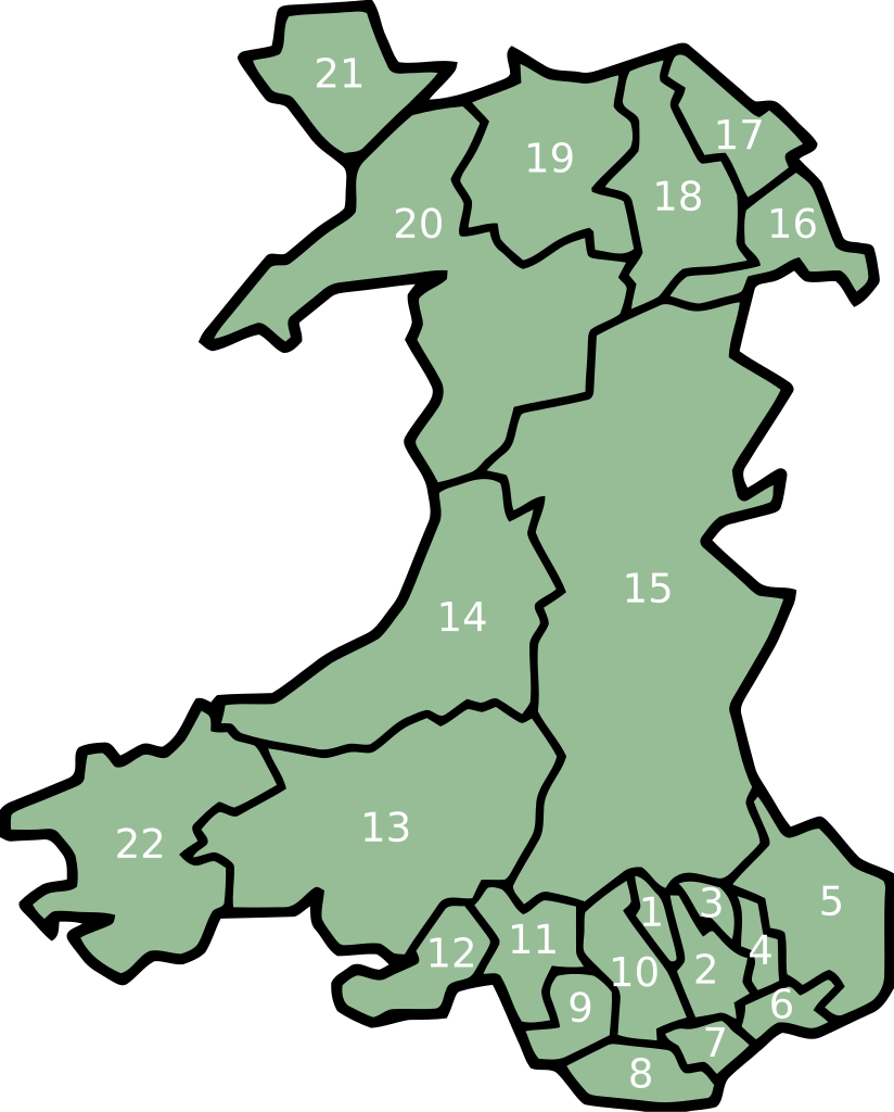
- Merthyr Tydfil/Merthyr Tudful
- Caerphilly/Caerffili
- Blaenau Gwent
- Torfaen/Tor-faen
- Monmouthshire/Sir Fynwy
- Newport/Casnewydd
- Cardiff/Caerdydd
- Vale of Glamorgan/Bro Morgannwg
- Bridgend/Pen-y-bont ar Ogwr
- Rhondda Cynon Taff/Rhondda Cynon Tâf
- Neath Port Talbot/Castell-nedd Port Talbot
- Swansea/Abertawe
- Carmarthenshire/Sir Gaerfyrddin
- Ceredigion
- Powys
- Wrexham/Wrecsam
- Flintshire/Sir y Fflint
- Denbighshire/Sir Ddinbych
- Conwy
- Gwynedd
- Isle of Anglesey/Ynys Môn
- Pembrokeshire/Sir Benfro
File history
Click on a date/time to view the file as it appeared at that time.
| Date/Time | Thumbnail | Dimensions | User | Comment | |
|---|---|---|---|---|---|
| current | 02:06, 12 February 2008 | | 500 × 621 (50 KB) | Marnanel (talk | contribs) | This version has all the extra SVG-cruft removed, all counties in separate groups, and the "id" field of each group set to the Welsh name of each county rather than a number. {{Information |Description=Same as Image:Map Cymru 1996 heb enwau.svg, but |
You cannot overwrite this file.
File usage on Commons
There are no pages that use this file.
File usage on other wikis
The following other wikis use this file:
- Usage on br.wikipedia.org
- Usage on el.wikipedia.org
- Usage on en.wikipedia.org
- Usage on eu.wikipedia.org
- Britainia Handia
- Gales
- Cardiff
- Llanfairpwllgwyngyll
- Swansea
- Gwynedd
- Denbighshire
- Ynys Môn
- Carmarthenshire
- Ceredigion
- Newport (Gales)
- Merthyr Tydfil
- Vale of Glamorgan
- Blaenau Gwent
- Torfaen
- Monmouthshire
- Pembrokeshire
- Conwy
- Flintshire
- Wrecsam
- Bridgend
- Rhondda Cynon Taf
- Castell-nedd Port Talbot
- Powys
- Portmeirion
- Blaenau Ffestiniog
- Pwllheli
- Txantiloi:Galesko eskualde aurkibidea
- Galesko azpibanaketak
- Bangor (Gales)
- Cricieth
- Harlech
- Llanbedr
- Aberangell
- Aberdesach
- Aberdyfi
- Abererch
- Abergeirw
- Abergwyngregyn
- Abergynolwyn
- Aberllefenni
- Abersoch
- Abertrinant
- Afon Wen
- Arthog
- Bala (Gales)
View more global usage of this file.