File:MassifDesBauges 1024.jpg

Original file (970 × 566 pixels, file size: 46 KB, MIME type: image/jpeg)
Captions
Captions
| Description |
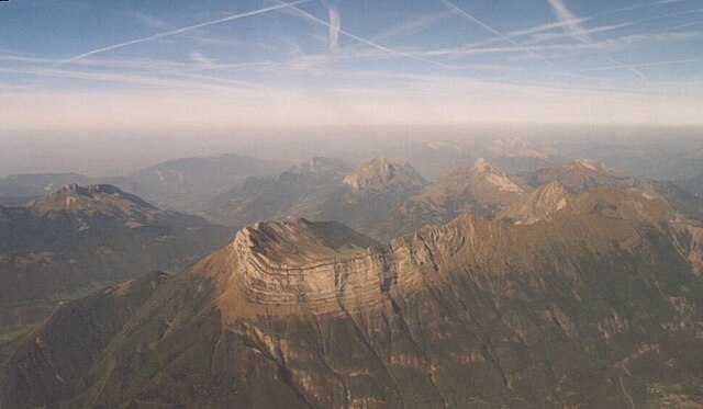
fr:Massif des Bauges - vue d'avion de la partie est - (c) 2003 Didier Halatre. La photo a été prise d'avion, un peu au sud de la verticale de fr:Saint-Pierre d'Albigny à 10 500' (env. 3 200 m) vers le nord, mi-septembre 2003. Temps beau mais brumeux dans le lointain. Au premier plan, on a l'Arclusaz (Dent d'Arclusaz, 2040 m) avec sa forme caractéristique. À l'extrême-droite (est), on a le Col de Tamié, en repartant vers la gauche (vers l'oest), on a la Pointe de la Sambuy (2198 m), l'Arcalod (2217 m), la Montagne du Charbon avec le Trélod (2181 m), le Roc des Bœufs (1774 m) et le Semnoz (1699 m) dans le lointain. À gauche (ouest), derrière l'Arclusaz, c'est le Grand Colombier (2043 m). La fr:lac d'Annecy se trouve derrière la Montagne du Charbon et le Roc des Bœufs, on distingue à l'arrière-plan dans la brume, le massif de la Tournette qui appartient au fr:massif des Bornes. |
| Source | |
| Author | User Didier on fr.wikipedia |
| Permission (Reusing this file) |
Released under the GNU Free Documentation License. |
| Other versions |
Originally from fr.wikipedia; description page is (was) here * 28 septembre 2003 à 12:45 [[:fr:User:Didier|Didier]] 1023×657 (59 057 octets) <span class="comment">(Massif des Bauges - vue d'avion de la partie est - (c) 2003 Didier Halatre, sous licence GNU FDL)</span> |

|
Permission is granted to copy, distribute and/or modify this document under the terms of the GNU Free Documentation License, Version 1.2 or any later version published by the Free Software Foundation; with no Invariant Sections, no Front-Cover Texts, and no Back-Cover Texts. A copy of the license is included in the section entitled GNU Free Documentation License. |
| This file is licensed under the Creative Commons Attribution-Share Alike 3.0 Unported license. | ||
| ||
| This licensing tag was added to this file as part of the GFDL licensing update. |
(Uploaded using CommonsHelper or PushForCommons)
| Annotations | This image is annotated: View the annotations at Commons |
File history
Click on a date/time to view the file as it appeared at that time.
| Date/Time | Thumbnail | Dimensions | User | Comment | |
|---|---|---|---|---|---|
| current | 17:13, 8 December 2022 | | 970 × 566 (46 KB) | Rémih (talk | contribs) | Cropped 5 % horizontally, 14 % vertically, rotated -5.5° using CropTool with precise mode. |
| 13:51, 1 September 2006 |  | 1,023 × 657 (58 KB) | Nicke L (talk | contribs) | {{Information| |Description= fr:Massif des Bauges - vue d'avion de la partie est - (c) 2003 Didier Halatre.<br /> Permission vous est donnée de copier, distribuer et/ou modifier ce document selon les termes de la Licence G |
You cannot overwrite this file.
File usage on Commons
The following 2 pages use this file:
File usage on other wikis
The following other wikis use this file:
- Usage on arz.wikipedia.org
- Usage on de.wikipedia.org
- Usage on el.wikipedia.org
- Usage on en.wikipedia.org
- Usage on en.wikivoyage.org
- Usage on eo.wikipedia.org
- Usage on fr.wikipedia.org
- Usage on fr.wikivoyage.org
- Usage on hu.wikipedia.org
- Usage on it.wikipedia.org
- Usage on lld.wikipedia.org
- Usage on nl.wikipedia.org
- Usage on nn.wikipedia.org
- Usage on pl.wikipedia.org
- Usage on sv.wikipedia.org
- Usage on vi.wikipedia.org
- Usage on www.wikidata.org