File:Map of Lilliput - Gulliver's Travels 1726 edition.png
(Redirected from File:Moll - Map of Lilliput.png)

Size of this preview: 352 × 599 pixels. Other resolutions: 141 × 240 pixels | 400 × 681 pixels.
Original file (400 × 681 pixels, file size: 187 KB, MIME type: image/png)
Captions
Captions
Add a one-line explanation of what this file represents
Summary[edit]
| Description |
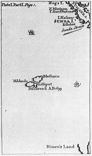
English: Map of Lilliput, for the 1726 edition of Jonathan Swift's Gulliver's Travels (or, Travels into Several Remote Nations of the World, 1726). Lilliput is situated south of Sumatra and north of "Dimen's Land" (Van Diemen's Land (Tasmania)?). Real islands in the far neigbourhood are nowadays the Cocos (Keeling) Islands (Australia) and Christmas Island (Great-Britain) and further south the pair Île Amsterdam (Amsterdam Island, Amsterdam or Nieuw-Amsterdam) and Île Saint-Paul at a distance of 85 km, which resemble the pair Blefuscu and Lilliput in the novel Gulliver's Travels. |
| Date | |
| Source | The 1726 edition of Jonathan Swift's Lemuel Gulliver's travels into several remote nations of the world |
| Author | Benjamin Motte, printer, after the style of Herman Moll |
Licensing[edit]
|
This is a faithful photographic reproduction of a two-dimensional, public domain work of art. The work of art itself is in the public domain for the following reason:
The official position taken by the Wikimedia Foundation is that "faithful reproductions of two-dimensional public domain works of art are public domain".
This photographic reproduction is therefore also considered to be in the public domain in the United States. In other jurisdictions, re-use of this content may be restricted; see Reuse of PD-Art photographs for details. | ||||
File history
Click on a date/time to view the file as it appeared at that time.
| Date/Time | Thumbnail | Dimensions | User | Comment | |
|---|---|---|---|---|---|
| current | 20:25, 24 September 2016 | | 400 × 681 (187 KB) | Cmdrjameson (talk | contribs) | Compressed with pngout. Reduced by 93kB (33% decrease). |
| 15:10, 22 September 2005 |  | 400 × 681 (281 KB) | Frank Schulenburg (talk | contribs) | Hermann Moll: ''Map of Lilliput'', for the 1726 edition of Jonathan Swift's ''Lemuel Gulliver's travels into several remote nations of the world'' {{Creator:Herman Moll}} |
You cannot overwrite this file.
File usage on Commons
The following 5 pages use this file:
File usage on other wikis
The following other wikis use this file:
- Usage on als.wikipedia.org
- Usage on de.wikipedia.org
- Usage on en.wikipedia.org
- Usage on eo.wikipedia.org
- Usage on eu.wikipedia.org
- Usage on fa.wikipedia.org
- Usage on fi.wikipedia.org
- Usage on fr.wikipedia.org
- Usage on hr.wikipedia.org
- Usage on it.wikipedia.org
- Usage on it.wikiquote.org
- Usage on ko.wikipedia.org
- Usage on nl.wikipedia.org
- Usage on pt.wikipedia.org
- Usage on ru.wikipedia.org
- Usage on sq.wikipedia.org
- Usage on uk.wikipedia.org