File:Nares strait border (Kennedy channel).png

Fichier d’origine (1 765 × 1 249 pixels, taille du fichier : 124 kio, type MIME : image/png)
Légendes
Légendes

|
Cette image (de type carte) devrait être recréée dans un format vectoriel, en tant que fichier SVG. Cela offrirait plusieurs avantages : voir Commons:Media for cleanup pour plus d'informations. Si une version SVG de cette image est déjà disponible, merci de bien vouloir l'envoyer. Après cela, remplacez ce modèle par {{vector version available|nouveau nom d'image.svg}}.
|
| Description |
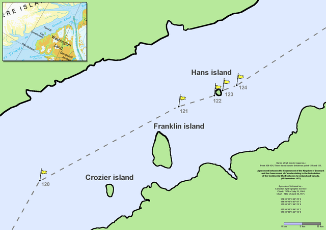
en:Nares Strait (en:Kennedy Channel) border (approx.) Point 120–124. There is no border between point 122 and 123. Agreement between the Government of the Kingdom of Denmark and the Government of Canada relating to the Delimitation of the Continental Shelf between Greenland and Canada. (17 December 1973) Agreement is based on en:Canadian Hydrographic Service charts 7071 of July 31, 1964 and 7072 of April 30, 1971
|
| Date | Commons upload by File Upload Bot (Magnus Manske) 10:54, 7 June 2006 (UTC) |
| Source |
Ce fichier est disponible selon les termes de la licence Creative Commons Attribution 2.5 Générique.
|
| Auteur | User Twthmoses on en.wikipedia |
Originally from en.wikipedia; description page is (was) here
.png)
- 06:02, 29 July 2005 Twthmoses 1765x1249 (196,934 bytes) ([[:en:Nares strait]] border (approx.) Point 120-124. There is no border between point 122 and 123. ''Agreement between the Government of the Kingdom of Denmark and the Government of Canada relating to the Delimitation of the Continental Shelf between Greenla)
Historique du fichier
Cliquer sur une date et heure pour voir le fichier tel qu'il était à ce moment-là.
| Date et heure | Vignette | Dimensions | Utilisateur | Commentaire | |
|---|---|---|---|---|---|
| actuel | 24 mars 2015 à 10:32 | | 1 765 × 1 249 (124 kio) | RokerHRO (d | contributions) | optipng -o7 -i0 → 35.36% decrease |
| 7 juin 2006 à 10:54 |  | 1 765 × 1 249 (192 kio) | File Upload Bot (Magnus Manske) (d | contributions) | {{Information| |Description= en:Nares Strait (en:Kennedy Channel) border (approx.) Point 120-124. There is no border between point 122 and 123. ''Agreement between the Government of the Kingdom of Denmark and the Government of Canada relating |
Vous ne pouvez pas remplacer ce fichier.
Utilisations locales du fichier
La page suivante utilise ce fichier :
Utilisations du fichier sur d’autres wikis
Les autres wikis suivants utilisent ce fichier :
- Utilisation sur ar.wikipedia.org
- Utilisation sur az.wikipedia.org
- Utilisation sur bcl.wikipedia.org
- Utilisation sur be-tarask.wikipedia.org
- Utilisation sur be.wikipedia.org
- Utilisation sur bn.wikipedia.org
- Utilisation sur ca.wikipedia.org
- Utilisation sur ceb.wikipedia.org
- Utilisation sur cs.wikipedia.org
- Utilisation sur da.wikipedia.org
- Utilisation sur de.wikipedia.org
- Utilisation sur en.wikipedia.org
- Utilisation sur en.wikiversity.org
- Utilisation sur eo.wikipedia.org
- Utilisation sur es.wikipedia.org
- Utilisation sur et.wikipedia.org
- Utilisation sur fa.wikipedia.org
- Utilisation sur fr.wikipedia.org
- Utilisation sur fy.wikipedia.org
- Utilisation sur he.wikipedia.org
Voir davantage sur l’utilisation globale de ce fichier.
.png)
.png&oldid=729478319)