File:Nisyros.jpg

Fichier d’origine (1 236 × 1 146 pixels, taille du fichier : 169 kio, type MIME : image/jpeg)
Légendes
Légendes
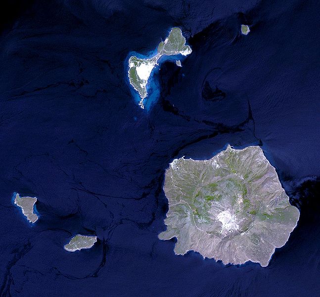
Nisyros Island, Aegean Sea (JPG) (173,039 bytes) ( 1,236 x 1,146 ) Nisyros is an active volcano in the Eastern edge of the South Aegean volcanic arc. It covers an area of 41.2 square kilometers and reaches a height of 698 meters. It is surrounded by 4 other small uninhabited volcanic islets. Nisyros is the youngest volcanic cone in the Aegean. Major volcanic activity is roughly estimated to have ended about 30,000 - 15,000 years ago. Since then superheated geothermal fluids triggered hydrothermal explosions, blasting the covering formations. Ten impressive craters of hydrothermal explosions with a diameter up to 300 m decorate the southeast part of the caldera floor. The most recent was created in 1887. This simulated natural color ASTER image is centered near 36.6 degrees north longitude, 27.2 degrees east latitude, covers an area of 18.5 x 17.2 km, and was acquired on July 29, 2004.
Please give credit for these images to: NASA/GSFC/METI/ERSDAC/JAROS, and U.S./Japan ASTER Science Team
| Ce fichier provient de la NASA. Sauf exception, les documents créés par la NASA ne sont pas soumis à copyright. Pour plus d'informations, voir la politique de copyright de la NASA. | ||
 |
Attention :
|
Historique du fichier
Cliquer sur une date et heure pour voir le fichier tel qu'il était à ce moment-là.
| Date et heure | Vignette | Dimensions | Utilisateur | Commentaire | |
|---|---|---|---|---|---|
| actuel | 31 mai 2005 à 22:33 | | 1 236 × 1 146 (169 kio) | Fxer~commonswiki (d | contributions) | [http://asterweb.jpl.nasa.gov/gallery-detail.asp?name=nisyros Nisyros Island, Aegean Sea] (JPG) (173,039 bytes) ( 1,236 x 1,146 ) Nisyros is an active volcano in the Eastern edge of the South Aegean volcanic arc. It covers an area of 41.2 square kilometer |
Vous ne pouvez pas remplacer ce fichier.
Utilisations locales du fichier
La page suivante utilise ce fichier :
Utilisations du fichier sur d’autres wikis
Les autres wikis suivants utilisent ce fichier :
- Utilisation sur ab.wikipedia.org
- Utilisation sur be.wikipedia.org
- Utilisation sur bg.wikipedia.org
- Utilisation sur ca.wikipedia.org
- Utilisation sur ceb.wikipedia.org
- Utilisation sur de.wikipedia.org
- Utilisation sur el.wikipedia.org
- Utilisation sur en.wikipedia.org
- Utilisation sur es.wikipedia.org
- Utilisation sur fi.wikipedia.org
- Utilisation sur fr.wikipedia.org
- Utilisation sur gl.wikipedia.org
- Utilisation sur he.wikipedia.org
- Utilisation sur hr.wikipedia.org
- Utilisation sur hy.wikipedia.org
- Utilisation sur hyw.wikipedia.org
- Utilisation sur it.wikipedia.org
- Utilisation sur la.wikipedia.org
- Utilisation sur nl.wikipedia.org
- Utilisation sur nn.wikipedia.org
- Utilisation sur no.wikipedia.org
- Utilisation sur pl.wikipedia.org
- Utilisation sur pt.wikipedia.org
- Utilisation sur ru.wikipedia.org
- Utilisation sur uk.wikipedia.org
- Utilisation sur www.wikidata.org
- Utilisation sur zh.wikipedia.org