File:Oenosatellite.png
Jump to navigation
Jump to search
No higher resolution available.
Oenosatellite.png (530 × 532 pixels, file size: 298 KB, MIME type: image/png)
Captions
Captions
Add a one-line explanation of what this file represents
Summary
[edit]
| Description |
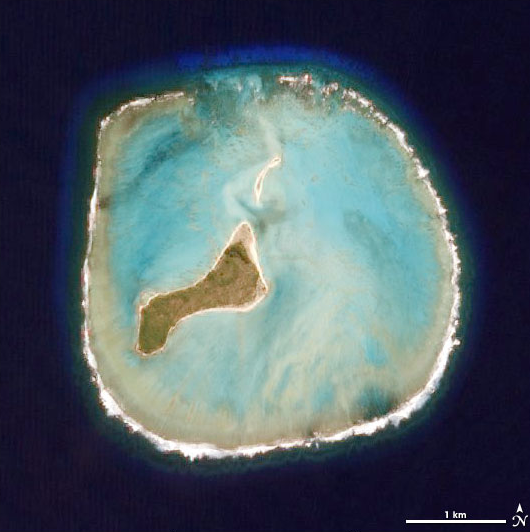
Deutsch: NASA-Satellitenbild des Oeno-Atolls (Pitcairninseln) im Pazifischen Ozean
English: NASA satellite picture of Oeno Atoll (Pitcairn Islands) in the Pacific Ocean
Taken by the Advanced Land Imager on NASA’s EO-1 satellite as part of a Mid-decadal Global Land Survey. |
| Date | |
| Source | http://earthobservatory.nasa.gov/Newsroom/NewImages/images.php3?img_id=17349 |
| Author | NASA |
Licensing
[edit]
| This file is in the public domain in the United States because it was solely created by NASA. NASA copyright policy states that "NASA material is not protected by copyright unless noted". (See Template:PD-USGov, NASA copyright policy page or JPL Image Use Policy.) | ||
 |
Warnings:
|
Original upload log
[edit]
Original Uploader was Ryanjo (talk) at 3 August 2006.
| Annotations | This image is annotated: View the annotations at Commons |
File history
Click on a date/time to view the file as it appeared at that time.
| Date/Time | Thumbnail | Dimensions | User | Comment | |
|---|---|---|---|---|---|
| current | 07:11, 29 November 2007 | | 530 × 532 (298 KB) | Telim tor (talk | contribs) | == Information == {{Information |Description= {{de|NASA-Satellitenbild des Oeno-Atolls im Pazifischen Ozean}} {{en|NASA Satellite Image of Oeno Atoll in the Pacific Ocean}} Taken by the Advanced Land Imager on NASA’s EO-1 satellite as part of a Mid-deca |
You cannot overwrite this file.
File usage on Commons
The following page uses this file:
File usage on other wikis
The following other wikis use this file:
- Usage on be.wikipedia.org
- Usage on ca.wikipedia.org
- Usage on ceb.wikipedia.org
- Usage on cs.wikipedia.org
- Usage on da.wikipedia.org
- Usage on en.wikipedia.org
- Usage on eo.wikipedia.org
- Usage on es.wikipedia.org
- Usage on fa.wikipedia.org
- Usage on frr.wikipedia.org
- Usage on hr.wikipedia.org
- Usage on id.wikipedia.org
- Usage on it.wikipedia.org
- Usage on la.wikipedia.org
- Usage on lt.wikipedia.org
- Usage on mrj.wikipedia.org
- Usage on my.wikipedia.org
- Usage on nl.wikipedia.org
- Usage on pih.wikipedia.org
- Usage on pl.wikipedia.org
- Usage on pt.wikipedia.org
- Usage on ru.wikipedia.org
- Usage on sk.wikipedia.org
- Usage on uk.wikipedia.org
- Usage on vi.wikipedia.org
- Usage on www.wikidata.org
- Usage on zh.wikipedia.org