File:OIC countries map.png
(Redirected from File:Oic countries map.png)

Size of this preview: 800 × 338 pixels. Other resolutions: 320 × 135 pixels | 640 × 270 pixels | 1,480 × 625 pixels.
Original file (1,480 × 625 pixels, file size: 43 KB, MIME type: image/png)
Captions
Captions
Add a one-line explanation of what this file represents
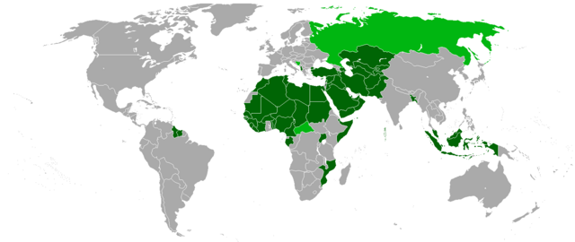
- Karte der Mitgliedsstaaten (dunkelgrün) und Beobachterstaaten (hellgrün) der Organisation der Islamischen Konferenz OIC
- Map of the member and observer states of the Organisation of the Islamic Conference OIC
Source[edit]
- Upload on http://de.wikipedia.org
- 01:09, 29. Jul 2005 . . St.Krekeler . . 969 x 579 (20772 Byte)

|
Permission is granted to copy, distribute and/or modify this document under the terms of the GNU Free Documentation License, Version 1.2 or any later version published by the Free Software Foundation; with no Invariant Sections, no Front-Cover Texts, and no Back-Cover Texts. A copy of the license is included in the section entitled GNU Free Documentation License. |
| This file is licensed under the Creative Commons Attribution-Share Alike 3.0 Unported license. | ||
| ||
| This licensing tag was added to this file as part of the GFDL licensing update. |

|
This organization map image could be re-created using vector graphics as an SVG file. This has several advantages; see Commons:Media for cleanup for more information. If an SVG form of this image is available, please upload it and afterwards replace this template with
{{vector version available|new image name}}.
It is recommended to name the SVG file “OIC countries map.svg”—then the template Vector version available (or Vva) does not need the new image name parameter. |
| Annotations | This image is annotated: View the annotations at Commons |
File history
Click on a date/time to view the file as it appeared at that time.
| Date/Time | Thumbnail | Dimensions | User | Comment | |
|---|---|---|---|---|---|
| current | 21:49, 2 February 2018 | | 1,480 × 625 (43 KB) | Maphobbyist (talk | contribs) | Added Maldives which is an OIC member and was forgotten. |
| 21:45, 2 February 2018 |  | 1,480 × 625 (43 KB) | Maphobbyist (talk | contribs) | Added borders of South Sudan which became independent in 2011 and which is not a member of the OIC. | |
| 18:05, 1 January 2018 |  | 1,480 × 625 (22 KB) | Nameless23 (talk | contribs) | Added missing western part of Malaysia | |
| 12:55, 12 June 2013 |  | 1,480 × 625 (32 KB) | Excolis (talk | contribs) | Maybe it works now | |
| 12:53, 12 June 2013 |  | 1,480 × 625 (32 KB) | Excolis (talk | contribs) | Now with Northern Cyprus as a light green marked state on the map. | |
| 15:17, 26 January 2011 |  | 1,480 × 625 (62 KB) | Kaiserslautern1993 (talk | contribs) | ||
| 15:06, 26 January 2011 |  | 1,480 × 625 (62 KB) | Kaiserslautern1993 (talk | contribs) | ||
| 17:02, 15 September 2008 |  | 1,357 × 628 (32 KB) | Milosevo (talk | contribs) | + Beobachter, + transparent background | |
| 21:29, 21 February 2008 |  | 1,357 × 628 (88 KB) | Leavade (talk | contribs) | Sahara hasn't signed | |
| 13:33, 29 January 2008 |  | 1,357 × 628 (52 KB) | Tariqhada (talk | contribs) | Reverted to version as of 17:09, 15 November 2007 |
You cannot overwrite this file.
File usage on Commons
The following page uses this file:
- File:Oic countries map.png (file redirect)
File usage on other wikis
The following other wikis use this file:
- Usage on als.wikipedia.org
- Usage on ar.wikipedia.org
- Usage on eo.wikipedia.org
- Usage on fr.wikipedia.org
- Usage on hr.wikipedia.org
- Usage on ja.wikipedia.org
- Usage on wo.wikipedia.org