File:Radar-angles.png
Jump to navigation
Jump to search

Size of this preview: 800 × 543 pixels. Other resolutions: 320 × 217 pixels | 640 × 434 pixels | 880 × 597 pixels.
Original file (880 × 597 pixels, file size: 119 KB, MIME type: image/png)
Captions
Captions
Add a one-line explanation of what this file represents
Summary[edit]
| Description |
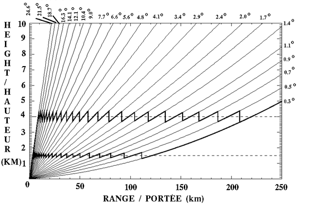
English: Trajectoiries at differents angles of the radar beam. This diagram is showing angles used by the Canadian Meteorological Service of en:Environment Canada. |
| Date | 23, 14:29 UTC |
| Source | Own work |
| Author | Pierre_cb |
| Other versions | en:Image:Radar-angles.png by Pierre_cb in English Wikipedia |
Licensing[edit]

|
Permission is granted to copy, distribute and/or modify this document under the terms of the GNU Free Documentation License, Version 1.2 or any later version published by the Free Software Foundation; with no Invariant Sections, no Front-Cover Texts, and no Back-Cover Texts. A copy of the license is included in the section entitled GNU Free Documentation License. |
| This file is licensed under the Creative Commons Attribution-Share Alike 3.0 Unported license. | ||
| ||
| This licensing tag was added to this file as part of the GFDL licensing update. |
File history
Click on a date/time to view the file as it appeared at that time.
| Date/Time | Thumbnail | Dimensions | User | Comment | |
|---|---|---|---|---|---|
| current | 22:16, 13 February 2009 | | 880 × 597 (119 KB) | Pierre cb (talk | contribs) | New image trying to correct resolution |
| 16:39, 13 February 2009 |  | 797 × 597 (105 KB) | Pierre cb (talk | contribs) | Same image but at a higher resolution | |
| 14:29, 23 May 2006 |  | 263 × 201 (23 KB) | Pierre cb (talk | contribs) | Trajectoiries at differents angles of the radar beam. This diagram is showing angles used by the Canadian Meteorological Service of Environment Canada. Author: Pierre_cb {{GFDL}} Category:Radar |
You cannot overwrite this file.
File usage on Commons
The following 2 pages use this file:
File usage on other wikis
The following other wikis use this file:
- Usage on en.wikipedia.org
- Usage on es.wikipedia.org
- Usage on et.wikipedia.org
- Usage on fr.wikipedia.org
- Usage on pt.wikipedia.org