File:SF Haight-Ashbury map.png
Jump to navigation
Jump to search
No higher resolution available.
SF_Haight-Ashbury_map.png (400 × 340 pixels, file size: 84 KB, MIME type: image/png)
Captions
Captions
Add a one-line explanation of what this file represents
Summary[edit]
| Description |
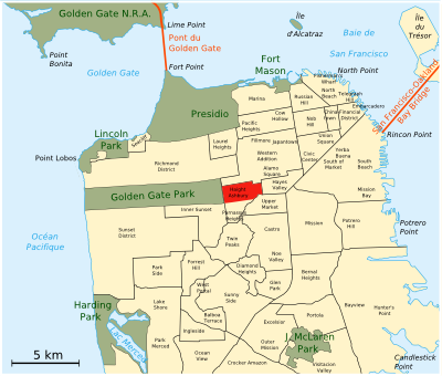
English: Locator map for Haight-Ashbury, San Francisco, California, United States
Français : Carte de situation d'Haight-Ashbury, San Francisco, USA
Svenska: Karta som visar Haight-Ashburys läge i San Francisco i Kalifornien i USA |
| Date | |
| Source | Own work |
| Author | Urban |
Licensing[edit]
| I, the copyright holder of this work, release this work into the public domain. This applies worldwide. In some countries this may not be legally possible; if so: I grant anyone the right to use this work for any purpose, without any conditions, unless such conditions are required by law. |
File history
Click on a date/time to view the file as it appeared at that time.
| Date/Time | Thumbnail | Dimensions | User | Comment | |
|---|---|---|---|---|---|
| current | 16:54, 31 December 2007 | | 400 × 340 (84 KB) | Urban~commonswiki (talk | contribs) | {{Information |Description=Carte de situation d'Haight-Ashbury, San Francisco, USA |Source=self-made |Date=31-12-2007 |Author= Urban |Permission= |other_versions= }} Category:Haight-Ashbury, San Francisco |
You cannot overwrite this file.
File usage on Commons
The following page uses this file:
File usage on other wikis
The following other wikis use this file:
- Usage on ckb.wikipedia.org
- Usage on de.wikipedia.org
- Usage on es.wikipedia.org
- Usage on eu.wikipedia.org
- Usage on fa.wikipedia.org
- Usage on fr.wikipedia.org
- Usage on it.wikipedia.org
- Usage on pl.wikipedia.org
- Usage on pt.wikipedia.org
- Usage on ru.wikipedia.org
- Usage on www.wikidata.org