File:Seasonal flooding in Thailand and Cambodia 2002 October 9.jpg

Fichier d’origine (1 150 × 1 500 pixels, taille du fichier : 376 kio, type MIME : image/jpeg)
Légendes
Légendes
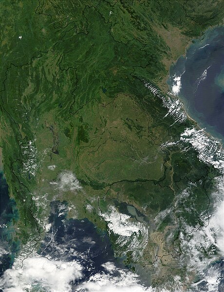
Seasonal flooding in Thailand and Cambodia
For two months, heavy, seasonal rains have inundated Thailand, flooding the countryside and killing over 120 people. This pair of true- and false-color images of Thailand was acquired on October 9, 2002, by the Moderate Resolution Imaging Spectroradiometer (MODIS) aboard NASA’s Terra spacecraft.
Thailand can be found just above the Gulf of Thailand, which is the body of water at the bottom of the image. The Chao Phraya River and the Yom River run down the center of the country into the gulf. Though the rivers now resemble narrow lakes in central Thailand, they normally would be faint in the image. In addition to the loss of life, 2.5 million people have suffered property damage or loss as a result of the floods. In many towns in central and northern Thailand people can only travel by boat, and many town centers have turned into floating markets.
In the large image, the entire Indochina Peninsula can be seen. Looking closely at the southeastern corner of the peninsula, mudflats and waterlogged farms can be seen emerging from abating floodwaters in Cambodia and Vietnam. Only a month ago these countries were experiencing some of the worst seasonal floods in years.
In this image, clouds are white and pink, water is black, and solid land is orange and brown.
http://visibleearth.nasa.gov/view_rec.php?id=3920
| Ce fichier provient de la NASA. Sauf exception, les documents créés par la NASA ne sont pas soumis à copyright. Pour plus d'informations, voir la politique de copyright de la NASA. | ||
 |
Attention :
|
Historique du fichier
Cliquer sur une date et heure pour voir le fichier tel qu'il était à ce moment-là.
| Date et heure | Vignette | Dimensions | Utilisateur | Commentaire | |
|---|---|---|---|---|---|
| actuel | 26 octobre 2005 à 01:58 | | 1 150 × 1 500 (376 kio) | Brian0918 (d | contributions) | Seasonal flooding in Thailand and Cambodia For two months, heavy, seasonal rains have inundated Thailand, flooding the countryside and killing over 120 people. This pair of true- and false-color images of Thailand was acquired on October 9, 2002, by th |
Vous ne pouvez pas remplacer ce fichier.
Utilisations locales du fichier
Les 4 pages suivantes utilisent ce fichier :
- Atlas of Cambodia
- Atlas of Thailand
- ព្រះរាជាណាចក្រកម្ពុជា
- File:Seasonal flooding in Thailand and Cambodia.jpg (redirection de fichier)
Utilisations du fichier sur d’autres wikis
Les autres wikis suivants utilisent ce fichier :
- Utilisation sur ar.wikipedia.org
- Utilisation sur ast.wikipedia.org
- Utilisation sur bn.wikipedia.org
- Utilisation sur da.wikipedia.org
- Utilisation sur en.wikipedia.org
- Utilisation sur es.wikipedia.org
- Utilisation sur fa.wikipedia.org
- Utilisation sur fr.wikipedia.org
- Utilisation sur gl.wikipedia.org
- Utilisation sur id.wikipedia.org
- Utilisation sur ru.wikipedia.org
- Utilisation sur th.wikipedia.org
- Utilisation sur uk.wikipedia.org
- Utilisation sur vi.wikipedia.org