File:Significant tornado alley.gif
Aller à la navigation
Aller à la recherche
Pas de plus haute résolution disponible.
Significant_tornado_alley.gif (512 × 360 pixels, taille du fichier : 8 kio, type MIME : image/gif)
Légendes
Légendes
Ajoutez en une ligne la description de ce que représente ce fichier
Description[modifier]
| Description |
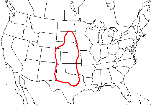
English: A map of the united states with Tornado Alley outlined, here defined as the area where approximately 1 day or greater per decade was near (25 mi; 40 km) a significant (F2 or stronger) tornado. |
| Source | http://www.nssl.noaa.gov/hazard/svrwxmisc.html http://www.nssl.noaa.gov/hazard/img/sigtoralley.gif |
| Auteur | NSSL |
Conditions d’utilisation[modifier]
Cette image est dans le domaine public car son contenu provient de la
National Oceanic and Atmospheric Administration , réalisé par un employé dans le cadre de ses activités professionnelles.
|
- The NOAA emblem is the property of the U.S. Government and a trademark of the United States Department of Commerce.
Historique du fichier
Cliquer sur une date et heure pour voir le fichier tel qu'il était à ce moment-là.
| Date et heure | Vignette | Dimensions | Utilisateur | Commentaire | |
|---|---|---|---|---|---|
| actuel | 20 octobre 2006 à 07:23 | | 512 × 360 (8 kio) | Runningonbrains (d | contributions) | {{Information |Description=A map of the united states with Tornado Alley outlined, here defined as the area where approximately 1 day or greater per decade contained a significant tornado. |Source=http://www.nssl.noaa.gov |
Vous ne pouvez pas remplacer ce fichier.
Utilisations locales du fichier
Aucune page n’utilise ce fichier.
Utilisations du fichier sur d’autres wikis
Les autres wikis suivants utilisent ce fichier :
- Utilisation sur de.wikipedia.org
- Utilisation sur en.wikipedia.org
- Utilisation sur fi.wikipedia.org
- Utilisation sur fr.wikipedia.org
- Utilisation sur gl.wikipedia.org
- Utilisation sur it.wikipedia.org
- Utilisation sur lt.wikipedia.org
- Utilisation sur pt.wikipedia.org
- Utilisation sur ru.wikipedia.org
- Utilisation sur simple.wikipedia.org
- Utilisation sur uk.wikipedia.org