File:Uk-map.svg
Aller à la navigation
Aller à la recherche

Taille de cet aperçu PNG pour ce fichier SVG : 271 × 599 pixels. Autres résolutions : 108 × 240 pixels | 217 × 480 pixels | 347 × 768 pixels | 463 × 1 024 pixels | 927 × 2 048 pixels | 1 021 × 2 255 pixels.
Fichier d’origine (Fichier SVG, nominalement de 1 021 × 2 255 pixels, taille : 204 kio)
Légendes
Légendes
Ajoutez en une ligne la description de ce que représente ce fichier
Description[modifier]
| Description |
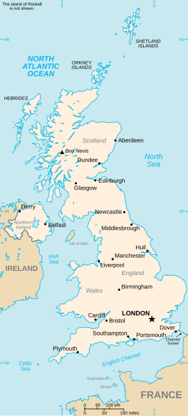
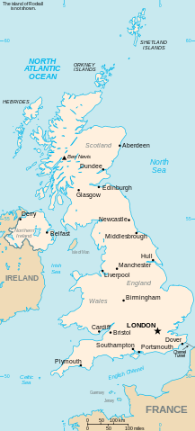
Vector version of CIA WorldBook map of the United Kingdom. Mercator projection. Vector information is from the CIA World DataBank II, and hence in the public domain. |
| Date | 23 juillet 2006 (date de téléversement originale) |
| Source | CIA World Factbook |
| Auteur | CIA |
| Autres versions |
|


Conditions d’utilisation[modifier]
Cette image est dans le domaine public parce que son contenu provient du World Factbook, édité par la Central Intelligence Agency des États-Unis d’Amérique.
|
 |
Historique du fichier
Cliquer sur une date et heure pour voir le fichier tel qu'il était à ce moment-là.
| Date et heure | Vignette | Dimensions | Utilisateur | Commentaire | |
|---|---|---|---|---|---|
| actuel | 5 mars 2024 à 06:22 | | 1 021 × 2 255 (204 kio) | Haziq Faruqi (d | contributions) | File uploaded using svgtranslate tool (https://svgtranslate.toolforge.org/). Added translation for ms. |
| 6 novembre 2023 à 17:28 |  | 1 021 × 2 255 (185 kio) | Belbury (d | contributions) | Reverted to version as of 23:32, 23 July 2006 (UTC) better spacing before | |
| 18 avril 2007 à 13:43 |  | 1 021 × 2 255 (128 kio) | Tene~commonswiki (d | contributions) | Cleanup | |
| 23 juillet 2006 à 23:32 |  | 1 021 × 2 255 (185 kio) | Wereon (d | contributions) | added scale | |
| 23 juillet 2006 à 22:55 |  | 1 021 × 2 255 (189 kio) | Wereon (d | contributions) | Vector version of CIA WorldBook map of the United Kingdom. Vector information is from the CIA World DataBank II, and hence in the public domain. |
Vous ne pouvez pas remplacer ce fichier.
Utilisations locales du fichier
Les 7 pages suivantes utilisent ce fichier :
Utilisations du fichier sur d’autres wikis
Les autres wikis suivants utilisent ce fichier :
- Utilisation sur ar.wikipedia.org
- Utilisation sur arz.wikipedia.org
- Utilisation sur be-tarask.wikipedia.org
- Utilisation sur da.wikipedia.org
- Utilisation sur de.wikipedia.org
- Utilisation sur de.wikivoyage.org
- Utilisation sur el.wikipedia.org
- Utilisation sur en.wikipedia.org
- Geography of the United Kingdom
- Wikipedia:Recent additions 12
- List of United Kingdom locations
- List of United Kingdom locations: Boa-Bot
- List of United Kingdom locations: Ia-Im
- List of United Kingdom locations: J
- List of United Kingdom locations: Na-Nev
- List of United Kingdom locations: Q
- List of United Kingdom locations: V
- List of United Kingdom locations: X-Z
- List of United Kingdom locations: Bab-Bal
- List of United Kingdom locations: Peo-Pn
- List of United Kingdom locations: Bre-Bri
- List of United Kingdom locations: Bea-Bem
- List of United Kingdom locations: Bam-Bap
- List of United Kingdom locations: Bar
- List of United Kingdom locations: Bas-Baz
- List of United Kingdom locations: Aa-Ak
- List of United Kingdom locations: Al
- List of United Kingdom locations: Am-Ar
- List of United Kingdom locations: As-Az
- List of United Kingdom locations: Bou-Boz
- List of United Kingdom locations: Bur-Bz
- List of United Kingdom locations: Bru-Bun
- List of United Kingdom locations: Ca-Cap
- List of United Kingdom locations: Car-Cd
- List of United Kingdom locations: Chi-Ck
- List of United Kingdom locations: Com-Cor
- List of United Kingdom locations: Cl-Cn
- List of United Kingdom locations: Co-Col
- List of United Kingdom locations: Cos-Cou
- List of United Kingdom locations: Cre-Croc
- List of United Kingdom locations: Cru-Cu
- List of United Kingdom locations: Da-Dam
- List of United Kingdom locations: De-Dee
- List of United Kingdom locations: Eat-Ee
- List of United Kingdom locations: Ea-Eass
- List of United Kingdom locations: East A-East D
- List of United Kingdom locations: Do-Dor
- List of United Kingdom locations: Ds-Dz
- List of United Kingdom locations: Ef-El
- List of United Kingdom locations: Em-Ez
- List of United Kingdom locations: Fa-Fe
Voir davantage sur l’utilisation globale de ce fichier.