File:Valais.png
Jump to navigation
Jump to search

Size of this preview: 800 × 538 pixels. Other resolutions: 320 × 215 pixels | 640 × 431 pixels | 1,024 × 689 pixels | 1,280 × 861 pixels | 3,013 × 2,027 pixels.
Original file (3,013 × 2,027 pixels, file size: 5.74 MB, MIME type: image/png)
Captions
Captions
Add a one-line explanation of what this file represents
Summary
[edit]
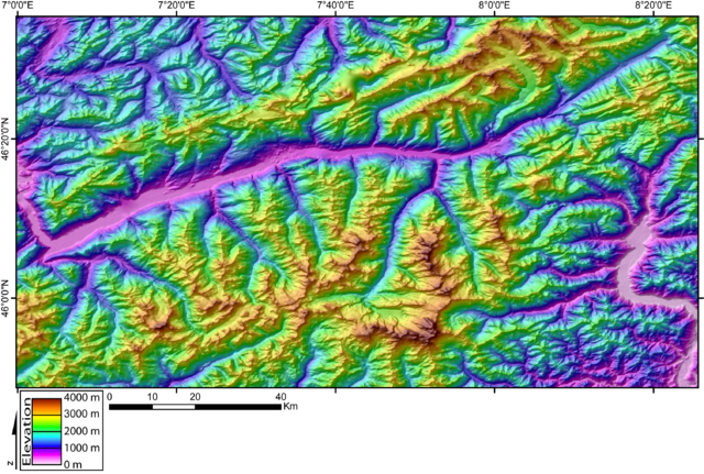
| Description | DEM of the Valais area (Swiss Alps) created by Jide from the 90 pixel size SRTM dataset. The large E-W valley in the middle of the picture is the Rhone valley. To the NE, one can see the Aletsch Glacier, the biggest european glacier, coming from the Aar Massif. One can see the NE edge of the Mont-Blanc Massif to the SW of the picture. The wide valley the East is the Domodosola valley (Ticino, Switzerland).Zermatt is located roughly at 46 00' / 07 50'. |
| Date | 3 November 2005 (original upload date) |
| Source | No machine-readable source provided. Own work assumed (based on copyright claims). |
| Author | No machine-readable author provided. Jide~commonswiki assumed (based on copyright claims). |
Licensing
[edit]
| I, the copyright holder of this work, release this work into the public domain. This applies worldwide. In some countries this may not be legally possible; if so: I grant anyone the right to use this work for any purpose, without any conditions, unless such conditions are required by law. |
File history
Click on a date/time to view the file as it appeared at that time.
| Date/Time | Thumbnail | Dimensions | User | Comment | |
|---|---|---|---|---|---|
| current | 23:17, 3 November 2005 | | 3,013 × 2,027 (5.74 MB) | Jide~commonswiki (talk | contribs) | DEM of the Valais area (Swiss Alps) created by Jide from the 90 pixel size SRTM dataset. The large E-W valley in the middle of the picture is the Rhone valley. To the NE, one can see the Aletsch Glacier, the biggest european glacier, coming from the Aar M |
You cannot overwrite this file.
File usage on Commons
There are no pages that use this file.
File usage on other wikis
The following other wikis use this file:
- Usage on es.wikipedia.org
- Usage on fr.wikipedia.org