File:Via Appia.jpg

Original file (1,271 × 442 pixels, file size: 216 KB, MIME type: image/jpeg)
Captions
Captions
| Description |
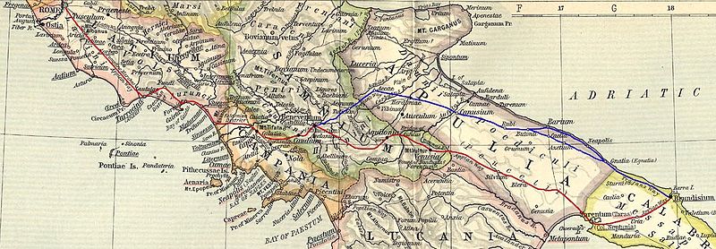
English: Ancient roman Appia road (from a William R. Shepherd 1911 map). The original track is in red color. In blue color a subsequent parallel track built under Traiano emperor and named Appia Traiana Italiano: Via Appia Antica (su mappa di William R. Shepherd, 1911). In colore rosso il tracciato originario, in blu l'Appia Traiana |
||||
| Date | |||||
| Source |
Based on a map from "Historical Atlas" by William R. Shepherd, New York, Henry Holt and Company, 1923 now in Public Domain. Reference: Reference Map of Ancient Italy, Southern Part Courtesy of the University of Texas Libraries, The University of Texas at Austin. [1] |
||||
| Author | EH101 | ||||
| Permission (Reusing this file) |
|
||||
![[1]](http://www.lib.utexas.edu/maps/historical/shepherd_1911/shepherd-c-030-031.jpg)
File history
Click on a date/time to view the file as it appeared at that time.
| Date/Time | Thumbnail | Dimensions | User | Comment | |
|---|---|---|---|---|---|
| current | 14:58, 15 March 2012 | 1,271 × 442 (216 KB) | EH101 (talk | contribs) | Fixed error from this message: The Via Appia Antica after Minturnae doesn't cross Suessa, Teanum Sidicinum, Cales (there was the end of the Via Latina), but cross the ancient city of Sinuessa and then reach Casilinum. --DenghiùComm (talk) 09:57, 14 J... | |
| 21:15, 7 March 2008 | 1,314 × 435 (215 KB) | EH101 (talk | contribs) | {{Information |Description={{en|Ancient roman Appia road (from a William R. Shepherd 1911 map). The original track is in red color. In blue color a subsequent parallel track built under Traiano emperor and named Appia Traiana}} {{it|Via Appia Antica (su m | ||
| 20:55, 16 May 2007 | 1,304 × 391 (165 KB) | EH101 (talk | contribs) | |||
| 23:51, 13 February 2006 | 1,304 × 391 (158 KB) | Ilario (talk | contribs) | {{it|Via Appia Antica (su mappa di William R. Shepherd, 1911)}} Category:Rivers in Switzerland |
You cannot overwrite this file.
File usage on Commons
The following 2 pages use this file:
File usage on other wikis
The following other wikis use this file:
- Usage on bg.wikipedia.org
- Usage on da.wikipedia.org
- Usage on es.wikipedia.org
- Usage on fr.wikipedia.org
- Usage on it.wikipedia.org
- Usage on la.wikipedia.org
- Usage on pt.wikipedia.org
- Usage on ro.wikipedia.org
- Usage on sv.wikipedia.org